|
|
|
Sierra Nature Notes, Volume 6, January 2006
Sierra
Nevada Climate, 1650–1850
Scott Stine
Department of Geography and
Environmental Studies
California State University
Hayward, California
Excerpted
from Stine, Scott, 1996. Climate of the Sierra Nevada, 1650-1850. Chapter 2
(pp 25-30) in, Sierra Nevada Ecosystem Project, Final Report to Congress, v.
2: Assessments and Scientific Basis forManagement Options.
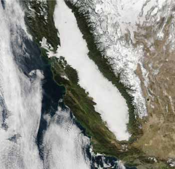 |
The Sierra Nevada in winter (January, 2005) |
Introduction
Climate exerts a profound influence on landscape by determining the flux
of both energy (solar radiation) and mass (rain, snow, and water vapor).
If climate changes significantly, the landscape can be expected to respond
geomorphologically, hydrologically, and biologically. These individual
responses, in turn, can feed on one another, creating a cascade of landscape
perturbations.
Around 1850, just as large numbers of Europeans descended on the Sierra Nevada for the first time, the region experienced a marked shift in climate, from the abnormally cool and moderately dry conditions of the previous two centuries (the “Little Ice Age”), to the relatively warm and wet conditions that have characterized the past 145 years. This climatic shift should concern land managers for two interrelated reasons: First, the landscape changes that have occurred since 1850 may not be entirely anthropogenic but rather attributable in part to the shift in climate. Second, the landscape of the immediate pre–gold rush period should not be considered an exact model for what the Sierra would be today had Europeans never colonized the region. Thus, attempts to restore “natural conditions” as part of an overall Sierra Nevada management plan should focus not on the pre-European landscape but rather on the landscape that would have evolved during the past century and a half in the absence of Europeans.
Using proxy climatic records, this paper explores the Sierra Nevada climate of the period 1650–1850 and compares it to that of the modern (post-1850) period. The focus is on climate at the decade to century scale, rather than on individual years or meteorological events. Emphasis is placed on records from lakes, glaciers, tree lines, and tree rings that can be resolved to time scales of multiple decades or less. Other types of proxy indicators, such as pollen and pack-rat records, while indispensable for illuminating multiple-century to millennial changes in climate, are not included in this analysis.
Climate Generalizations
Climate is not a landscape component as much as a landscape determinant.
It exerts an overriding influence on such landscape components as vegetation
(including its type, biomass, and distribution), hydrology (including the
size, distribution, fluctuations, and water quality of lakes and rivers),
soils (including their thickness, stability, and nutrient capacity), and
landforms (including their rates of formation and loss). It also strongly
influences other landscape determinants, the most important of which may
be fire (including its location, frequency, and intensity).
Climate is inherently changeable, whether by the decade, century, or millennium. It is inherently variable, with some periods characterized by frequent and/or wide departures from the average and others by infrequent and/or narrow departures. And it is inherently site-specific, differing even over small areas depending on such variables as topography, slope orientation, vegetation cover, and elevation. In a range as high, extensive in area, and complex in topography as the Sierra Nevada, the variety of local climates is too extensive to enumerate here. The following generalizations can be drawn, however:
Climate
in the Sierra, 1650–1850
Climate varies not only spatially but also temporally, with some periods
being relatively wet and others relatively dry, some relatively cool and
others warm. Putting aside for now the year-to-year and decade-to-decade
variations in climate, it is possible to characterize the period from the
mid-1600s to the mid-1800s as having been, by modern standards, abnormally
cool and moderately dry. This interval was preceded by several centuries
of cool and wet conditions and was followed by the relatively warm and
wet conditions of the past 145 years. Evidence for these generalizations
comes from several sources.
Mono Lake
Mono Lake, on the lee side of the central Sierra Nevada, receives its
inflow from the Rush, Lee Vining, and Mill Creek drainages. Since
1941, much of this inflow has been diverted by the Los Angeles
Department of Water and Power for domestic supply, forcing the
lake to low levels. But for these diversions, the lake surface
during the past century would have fluctuated within a narrow elevation
interval (± 2 m [6 ft]) centered on about
1,958 m (6,423 ft) (P. Vorster, telephone conversation with the author,
May 1995). This elevation is hereafter referred to as the “natural
level” of the modern period. Around 1650, Mono Lake attained a high
stand at 1,967.8 m (6,456 ft), 10 m (30 ft) higher than the calculated
natural level of the modern period (Stine 1987, 1990). Radiometrically
dated evidence for this high stand (and thus evidence for effectively wet
conditions) is seen today in the form of rooted stumps, sedimentary sequences,
and geomorphic stand lines. These same lines of evidence demonstrate that
between 1650 and about 1840 effectively drier conditions drove Mono Lake
to 1,948.9 m (6,394 ft)—9 vertical meters (29 ft) below the calculated “natural
level” of the modern period. This low level, corresponding to a surface
area approximately 79% that of the modern natural value, indicates that
the effective inflow to Mono Lake prior to 1850 was, on average, less than
79% of the effective inflow of the period 1937–79 (Stine 1987,
1990).
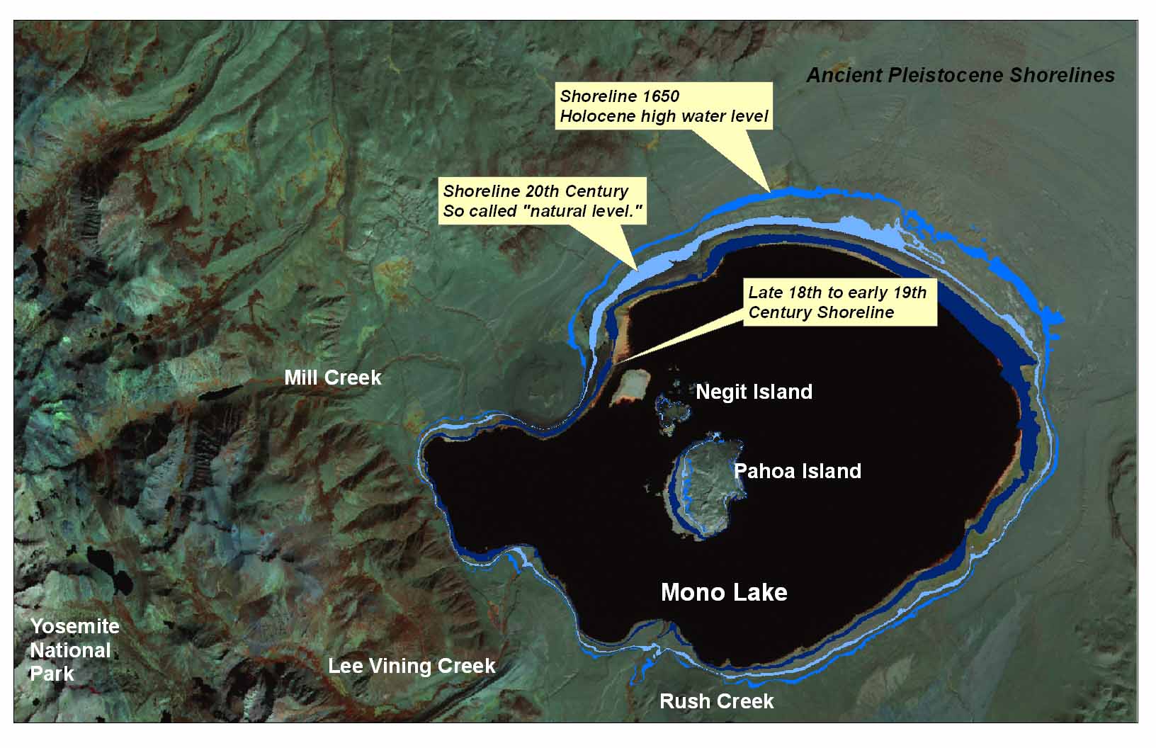 |
| Holocene shorelines of Mono Lake (Click map to enlarge) |
Owens Lake
Owens Lake is the natural sink for all eastern Sierra Nevada runoff
south of the Mono Basin. Diversion of the Owens River (Owens Lake’s main
feeder stream), first by irrigation interests in the Owens Valley and subsequently
by the Los Angeles Department of Water and Power, has desiccated the lake,
exposing the entire playa floor. Were it not for these diversions, Owens
Lake since the early 1860s would have stood within a narrow elevation interval
(±1 m [3 ft]) centered on about 1,095.5 m (3,594 ft). Such a lake
would cover the now dry lake floor with up to 15.8 m (52 ft) of water (Stine
1994). Sequences of lake-transgressive and lake-regressive deltaic sediments
exposed in the walls of the stream cuts adjacent to Owens Lake provide
evidence that around the half-century 1600–1650 effectively wet conditions
drove the shoreline to an elevation of 1,098.8 m (3,605 ft), creating a
lake with a surface area approximately 110% that of the modern natural
value. Effectively dry conditions prevailed during much of the ensuing
two centuries, forcing the lake to elevations below 1,088 m (3,570 ft)—more
than 7 m (24 ft) lower than the natural level of the modern period. This
low stand represents a surface area approximately 77% that of the natural
modern value, suggesting that effective inflow to the lake was more than
23% below the natural modern value (Stine 1994; Stine, unpublished data).
In summary, the closed lakes of the eastern Sierra Nevada are consistent in being dominated by declining levels and low stands during the period from the mid-1600s to the mid-1800s. In those two centuries the lakes attained elevations lower than those of the prior century (1550–1650) and lower than the “natural levels” of the twentieth century.
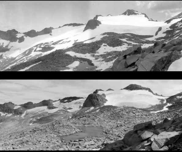 |
| A comparison
of Lyell Glacier, Yosemite National Park in 1903 (top) taken by G.K.
Gilbert, and 2003 (bottom) taken by
Hassan Basagic. From Hassan Basagic Twentieth Century Glacier Change in the Sierra Nevada, California |
Evidence from Sierra Nevada Glaciers
Following thousands of years of little or no glaciation, high elevation
cirques of the Sierra Nevada experienced ice accumulation for several
centuries prior to 1850 (Clark and Gillespie 1995; Curry 1969).
This period of minor glacier advance (typically less than 2 km),
first described in the Sierra by Matthes (1939), corresponds to
the “Little Ice Age”—a
period of cooling over much of the globe that began in the fourteenth
or fifteenth century and continued through the middle of the nineteenth
century (Grove 1988).
Based on the well-documented behavior of glaciers in the European Alps, Matthes (1939), speculated that these small ice bodies of the Sierra Nevada reached their maximum extent during the period 1850–55. Maps and photos produced by Russell (1885a, 1889) show that by the early 1880s the Lyell, McClure, and Dana Glaciers had begun to retreat from their maximum positions of the Little Ice Age, with the ice front lying several hundred feet (in the case of the Lyell Glacier) up the canyons from the terminal moraines. With the exception of a few years of net positive glacier balance (Curry 1969), this shrinkage, and the loss of many small ice patches, continued into the early decades of the twentieth century. Matthes (1939, 1942a, 1942b) noted that between 1933 and 1938 the Palisades Glacier thinned by 8.2 m (27 ft); that between 1931 and 1939 the East Lyell Glacier retreated 26.5 m (87 ft); and that between 1933 and 1941 the West Lyell Glacier thinned by 3.7 m (14 ft) and the East Lyell Glacier by 6.7 to 10.4 m (22 to 34 ft). Further shrinkage of the glaciers is evident from a comparison of the U.S. Geological Survey quadrangles from the late 1940s and early 1950s with those from the 1980s. Evidence thus indicates that the centuries prior to 1850 were abnormal in the context of Holocene climate, in that they favored ice accumulation in cirques of the high Sierra. Shortly after 1850 the glaciers began to retreat. With the exception of a few aberrant years, Sierran glaciers have experienced a net negative balance since that time.
Theoretically, this minor glaciation of the mid-sixteenth through mid-nineteenth centuries is attributable to some combination of increased precipitation (leading to greater accumulation) and decreased temperature (leading to less melting and sublimation). Since the lake level records presented earlier in this chapter are consistent in suggesting that climate was relatively dry during this period, it might be concluded, as a working hypothesis, that relatively low temperatures caused the advance of the ice. Various types of dendroclimatological evidence also comport with this hypothesis. The dendroclimatic record [see original article – ed], in fact, verifies that climate was both relatively cool and relatively dry during the centuries preceding the California gold rush.
Summary and Discussion
A combination of records from lakes, glaciers, tree rings, and tree
lines in and adjacent to the Sierra Nevada indicates that, in general,
the period from around 1650 to 1850 was characterized by anomalously
cool, moderately dry conditions. After being driven to their highest
levels in several millennia by effectively high Sierran runoff,
Mono, Pyramid, and Owens Lakes began to fall around 1650. Physical,
biotic, and historical evidence indicates that during the 1840s
and 1850s these lakes stood well below their modern natural levels,
leading to the inference that effective inflow was perhaps 23%–34%
less than the modern value. By the early 1860s the lakes were rising
toward their modern natural levels in response to increased effective
runoff from the Sierra.
As the closed lakes of the eastern Sierra were falling to low levels between 1650 and 1850, glaciers were forming and advancing in the high Sierra, arguably for the first time during the Holocene (the postglacial period). (Note that the accumulation of ice in the cirques of the eastern Sierra Nevada played only an insignificant role in decreasing runoff from the Sierra during this period. The building of glaciers during the Little Ice Age is thus not, in and of itself, an explanation for the recession of the closed lakes.) Glacier increase, together with the hydrogen-isotope record from the White Mountain bristlecone pines and the tree-line depression in both the White Mountains and the Sierra, strongly suggests that the centuries prior to the California gold rush were the coolest of the past 8,000 and more years. The modern wasting of the glaciers, the upward expansion of alpine tree lines, and the hydrogen- isotope record all indicate that since 1850 the Sierra has experienced a marked warming.
Graumlich’s tree-ring record from the southern Sierra provides the most detailed view of variations in the latest Holocene climate. That record confirms that the period from 1650 to 1850 was generally dry, although it points up an important exception not evident in the lake or glacial records: the interval 1713–32 was anomalously wet. Graumlich’s work also provides corroboration that the period from 1650 to 1850 was, by both Holocene and modern standards, abnormally cool.
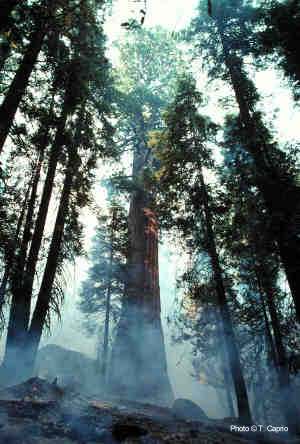 |
| Using fire scarred trees in the Redwood Mountain
area of Kings Canyon National Park, years of past occurrence and past
fire frequencies were determined. Prior to 1875 fire frequency averaged
9 yr on west-facing slopes and 16 yr on east-facing slopes. Photo © by Anthony Caprio NPS |
Implications for the Fire Regime in the Sierra Nevada
Based on an examination of burn scars in the tree rings of giant sequoias
(Sequoiadendron giganteum) at five groves on the west slope of the Sierra,
Swetnam (1993) reconstructed a 2,000-year-long fire history. Relating fire
size and fire frequency to climate series derived from tree rings of giant
sequoias and bristlecone pines, he documented a close decade- to century-scale
positive relationship between summer temperature and fire activity (frequency
and synchrony) and a close multiple-year-scale negative relationship between
precipitation and fire activity. He tentatively attributes these relationships
to high-frequency (years-scale) precipitation dependent changes in the
moisture content of fuels and low frequency (decade- to century-scale)
temperature-dependent changes in fuel production
Swetnam’s record indicates that throughout the period 1650–1850 fire frequency in the groves sustained its lowest level in 900 years, a result that would be expected, given the low temperatures of the Little Ice Age.
Equally expected would be an increase in fire frequency corresponding to the increase in temperature after 1850. This modern increase in fire frequency did not occur, however, probably for three reasons: decreased fuel loads due to sheep grazing, a decrease in ignition due to the demise of Native Californian culture, and fire suppression policies. Indeed, rather than increasing, fire frequency since 1850 has decreased to its lowest value of the past 2,000 years.
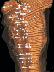 |
| A
fire may be recorded as a lesion in an annual ring when living cambium,
usually on the margins of a catface, is injuring by the heat of the
fire. Over time multiple injuries (fire scars) can occur. Photo © by Anthony Caprio NPS |
These findings underline the peculiarity of the modern fire regime in the Sierra Nevada: while the disparity between fire frequency of the modern period and that of the period 1650– 1850 is clearly large, the disparity between modern fire frequency and the frequency that would occur today absent European settlement is even larger.
Implications for Management of the Sierra Nevada
The period 1650–1850 is of great interest to Sierra Nevada land managers
because it is the last interval in which Europeans exerted little if any
influence on the Sierran landscape. It may be tempting to use the condition
of the landscape as it existed during this two-century period as a model
for what the Sierra would be today in the absence of Europeans. In a related
way, it may be tempting to attribute all landscape changes that have occurred
since 1850 to the agency of Europeans. There can be no question that many
of the changes that have occurred since 1850 are attributable to the activities
of Europeans. But it must be borne in mind that the European incursion closely
coincided with a marked shift in climate and that some of the landscape change
since 1850 may be, at least in part, attributable to that climate shift.
The magnitude of the shift underscores its potential importance in instigating
landscape change. In temperature, the shift was from the coldest century-scale
interval of the Holocene, as indicated by the tree-line and glacier records,
to one of the warmest periods of the past 4,000 years, as suggested by the
recent upward movement of the tree line. In moisture availability, the shift
was from moderate effective drought, as evidenced by the records of tree
rings and lake levels, to the relative wetness of the present century—a
century that appears, from the records of lake levels, to be the fourth-wettest
of the past 4,000 years (Stine 1990) and that includes the third-wettest
fifty-year interval (1937–86) of the past millennium (Graumlich 1993).
Thus it seems that, even if the European incursion had never occurred, the Sierra Nevada landscape of today would differ in significant ways from that of the immediate pre–gold rush period. With this in mind, attempts to restore “natural conditions” as part of an overall management plan should focus not on the pre-European landscape but rather on the landscape that would have evolved during the past century and a half in the absence of Europeans.
Further Reading
Stine,
Scott, 1990.
Late
Holocene fluctuations of Mono Lake, eastern California.
Palaeogeography, Palaeoclimatology, Palaeoecology v. 78, pp 333-381(1990).
Mono
Basin Clearinghouse
How
has climatic variation influenced treeline dynamics in the past?
Andrea H. Lloyd
Assistant Professor, Department of Biology, Middlebury College
The
Great Droughts of Y1K
Scott Stine, Ph.D
California State University, Hayward
Sierran
Treeline Dynamics in a Changing Climate
by
Andrew G. Bunn
PhD Candidate
Department of Land Resources and Environmental Science
Montana State University
Persistence
of pikas in two low-elevation national monuments in the western United
States
By Erik A. Beever, Ph.D.
Ecologist, U.S. Geological Survey, Forest and
Rangeland Ecosystem Science Center, 3200 SW Jefferson Way, Corvallis,
OR 97331.
Estimated
Ages of Some Large Giant Sequoias:
General Sherman Keeps Getting Younger
Nathan
L. Stephenson, Ph.D
U.S. Geological Survey, Western Ecological Research
Center, Sequoia and Kings Canyon Field Station.
USC Geology 150: Climate Change
Our Founder Questions? Go to About Our New Site |
Masthead
Photo from: |