|
|
|
Sierra Nature Notes, Volume 3, May 2003
Sierran Treeline Dynamics in a Changing Climate
Andrew G.
Bunn
PhD Candidate
Department of Land Resources and Environmental Science
Montana State University
106 AJM Johnson Hall Bozeman, MT 59717-3490, USA
voice: 406-994-2374 fax: 406-994-5122
email: abunn@montana.edu
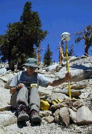 |
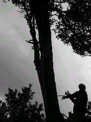
| Scientist at work: locking in the location with GPS. |
Hikers on the
Pacific Crest Trail in the High Sierra walk among some of the world's most
ancient trees and are unknowing witnesses to striking evidence of climate
change. From Cottonwood Pass south of Sequoia National Park to Donner Pass
north of Yosemite National Park, the PCT winds along the crest of the Sierra.
Hikers on the eastern crest of the High Sierra are granted an amazing sight:
dead trees rooted in the ground above the current treeline. These denizens
standing above where trees can live today are testaments to climates and forests
of an earlier age. A picture that I see when I close my eyes is treeline ebbing
and flowing up and down the mountainside over time scales of hundreds and
thousands of years. The task that has been put to me by my advisor, Dr. Lisa
Graumlich of the Big Sky Institute at Montana State University, is to develop
a computer model that will help us understand that flow. Our goal is to understand
impacts of climate on these forests and, ultimately, how we can use these
forests to shed light on present and future climate.
Alpine treeline is the transition area between forest and tundra on high mountains.
In most low elevation forests, the growth and establishment of trees is controlled
by competitive interactions and disturbances like fire and wind-throw (trees
blown down by high winds). High elevation treeline communities are removed
from many of these pressures by the cold and harsh environment and are more
strongly controlled by temperature and precipitation. The clean climate signal
that is expressed in this ecosystem makes the alpine treeline ecotone one
of the best places on earth to study climate variation. Another key to studying
alpine treeline is our ability to understand the growth and age of these trees
over past millennia.
Many people think
that that age of these trees is determined from carbon dating. In fact, though,
we know the age of these trees using the science of dendrochronology. Dendrochronology
is the dating and study of annual rings in trees. It is so accurate that the
calibration coefficients for carbon dating are derived from tree-ring analysis.
Dendrochronology as a discipline was developed by the astronomer A.E. Douglass
in the early 1900s. Douglass' first work concerned the frequency of sunspot
cycles but his major breakthrough was firmly dating the construction, occupation,
and abandonment of the famous pueblos and cliff dwellings of the American
Southwest. Since that time, the field has matured and is used widely in ecology,
geomorphology, hydrology, chemistry, archeology and climatology. The prefix
paleo can be added to all these studies as the study of the annual
rings necessarily goes back in time. The study of treeline in the Sierra involves
paleoecology and paleoclimatology.
Treeline position reflects climate through the rings that trees add each year
and by moving up and down slope. Because the climate of the eastern High Sierra
is cold and dry, dead wood is preserved for millennia. By cross dating the
annual pattern of living and dead wood it is possible to date the dead trees
above current treeline to a period of warmer temperatures (100 BC to AD 900)
that allowed trees to disperse up slope above current treeline. Periods of
drought (AD 1000 to 1400) and cool temperatures (AD 1500 to 1900) caused those
trees to die and treeline to move down to the current location.
The fundamental question that drives my research is whether this will happen
again. All of the information we have on the biology and physiology of trees
indicates that they were responding to a warmer climate. The international
scientific consensus is that climate is warming right now. If that is the
case, then will we be able to use tree regeneration patterns and growth rates
to determine if treeline is moving right now? If it is, what can those patterns
tell us about the magnitude of the current climate changes and what can it
tell us about the potential for future climate?
I am attacking this problem at three locations in the Sierra and two sites
in the Rockies. I have sites in Sequoia National Park at Cirque Peak and Bighorn
Plateau and around Yosemite National Park near Lee Vining Peak. These sites
are defined by the cold and dry conditions ideal for producing long, climatically
sensitive tree-ring chronologies. Each site has at least a 1000-year chronology
associated with it. The soils are formed from a granitic substrate and are
mostly shallow sand with low organic matter over a fractured-rock substrate.
Tree densities are low throughout all the sites (about 100 trees or krummholz
patches/ha; ha=hectare or 2.47 acres) and herbaceous plants are scarce
(< 1 plant/meter2).
Two species of tree, with very different physiognomies, are represented these
areas. Foxtail pine (Pinus balfouriana austrina) is present at the
Cirque Peak and Bighorn Plateau. P. balfouriana can be found roughly
between the 37th and 36th parallels in the Sierra Nevada at altitudes ranging
from 2700 m to 3700 m (8900 to 12,000 feet). The trees thrive on steep slopes
with little understory growth. They usually grow erect, unlike other timberline
trees that often form krummholz mats. The foxtail is most commonly found on
sites with very little soil development. Each tree has a deep, spreading root
system, much like a desert shrub, which may account for the low density in
foxtail forests. It can be found in pure forests nearest to the timberline,
but readily mixes with other conifers in the lower elevations of its distribution.
Unfortunately, little is known about foxtail reproduction, but their annual
rings have been a key to understanding the climate of the past millennium.
 |
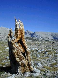 |
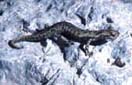
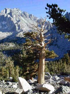
| An ancient foxtail pine at treeline near Cirque Peak in Sequoia National Park. The annual rings on this tree give clues about past climate. | A dead trunk above current treeline from a foxtail pine that lived about 1000 years ago near Bighorn Plateau in Sequoia National Park. |
Whitebark pine
(P. albicaulis) grows in the highest elevation forests and at timberline.
Its distribution is split into two broad sections, one following the British
Columbia Coast Ranges, the Cascade Range, and the Sierra Nevada, and the other
covering the Rocky Mountains from Wyoming to Alberta. Large seed crops are
produced at irregular intervals, with smaller crops and crop failures in between.
The large, heavy, and wingless seeds are dispersed primarily by Clark's Nutcracker
(Nucifraga columbiana). This huge volume of seeds dispersed (> 5,500
seeds / ha) combined with shallow rooting potential makes the whitebark niche
extraordinarily broad at treeline. This is amplified by the tendency of whitebark
pine to reproduce vegetatively in a prostrate, krummholz form. It occurs at
the Bighorn Plateau site and at the site in Yosemite.
 |
| A field assistant at the MSU Tree-Ring Lab, cores a whitebark pine. |
The first avenue
I'm pursuing for my research is examining the annual rings of growth patterns
of trees using increment cores. By doing this, I'm building on the considerable
amount of paleoclimatic data Graumlich and colleagues have assembled in the
Sierra for the past decade. The data we are gathering confirms the current
state of knowledge about global warming, namely that growth rate of trees
in the High Sierra is different now than any time in the past thousand years.
This research tells us when tree growth is changing but it is a little vague
on exactly where this is happening and it does very little to answer how these
growth patterns will impact the treeline ecosystem.
I'm faced with
a problem. There is a great deal of treeline in the Sierra. The terrain is
remote and rugged - my crew and I carry 90-pound packs over 15 miles and seven
thousand vertical feet to get to one of our sites. Given the sweat that goes
into this, I really need to know: where is the best place to study treeline?
To help make that decision, I'm using high-resolution satellite imagery and
technology from a Geographic Information System (GIS).
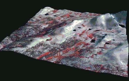 |
| The upper part of the Kern watershed at Bighorn Plateau in Sequoia National Pak is shown in this IKONOS satellite image, which is draped over a digital elevation model. |
 |
 |
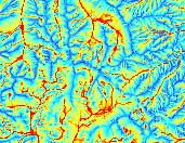 |
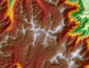
| A shaded elevation model is shown from Sequoia NP is on the top. For the same area (about 200 km2), a model of radiation load is shown in the center and a model of soil moisture is shown on the bottom. These layers can be incorporated into a GIS with tree growth rates to understand how the physical environment affects climate sensitivity. |
In the satellite
image shown above it is possible to map treeline positions. When that map
is combined with physical models of sunlight, wind, and water flow we can
infer which areas of treeline are most sensitive to climate. This substantially
narrows the potential areas we need to sample. This allows us to find areas
with the best quality tree rings and the areas that are experiencing tree
regeneration. In areas where we find seedlings establishing above the current
trees, we know that there is the potential for treeline to shift.
Some of the field assistants we hire have what might be the best summer job
in the world. We hire a few students to hike around some of the most beautiful
and remote areas of the High Sierra to map the locations of out most valuable
data: the dead wood above treeline. Armed with a Global Positioning System
receiver (and a bag of snacks) they traverse Sierran treelines in search of
forests-past. By mapping the locations and state of the dead wood above treeline,
we can determine under what physical conditions treeline can move upslope.
Because the High Sierra is only accessible for about 12 weeks a year, I have
the other 38 weeks to study the data we collect. When not in the field I'm
working on a computer model that simulates individual tree growth using tree
rings, the location of seedlings and dead wood, the underlying physical template
that the trees sit on, plus temperature and precipitation from the instrumental
record of weather. This is still very much a work in progress but the initial
data is promising.
The outcome of a computer model is not to reproduce the real world exactly.
That would be impossible and ultimately not very satisfying. Rather, the real
power of computer simulation models, whether they predict tree growth or corn
yields, is to forecast potential scenarios while fully specifying the elements
of the system we are uncertain about - what we can't know. If this can be
done with treeline, we can develop ideas about what kind of climate change
we would have to have to move treeline. We can play games with different predictions
of future climate and use that information with data on the natural variability
of tree growth over the last millennia to understand how the current patterns
fit into a longer time window. This model will teach us to ask better questions
and to put our observations into a bigger box of possibilities. Perhaps these
questions can help answer the degree of impact that people are having on climate
and the impacts that ecosystems will experience.
The High Sierra are a stunningly beautiful place to hike, but that beauty
is deceptive. The wind and sun blasted landscape of granite and trees feels
forbidding and permanent. The next time you hike over Kearsarge Pass or drive
over Tioga Pass to Lee Vining, you will know that these high elevation ecosystems
are dynamic recorders of climate. If you can think like a tree that lives
for a thousand years or more, you can then try to imagine the treelines moving
up and down slope in response to a constantly changing environment. How much
that landscape will change remains to be seen.
Suggested
Readings
Arno, S. F. (1973) Discovering
Sierra Trees (Yosemite Association, Yosemite National Park).
Graumlich, L. J. (1994) in Mountain Environments in Changing Climates,
ed. Beniston, M. (Routledge, London), pp. 167-179.
Intergovernmental Panel on Climate Change (1996) The Science of Climate
Change (Cambridge University Press, Cambridge).
Lloyd, A. H. & Graumlich, L. J. (1997) Ecology 78, 1199-1210.
Mann, M. E., Bradley, R. S., & Hughes, M. K. (1998) Nature 392
, 779-787.
Schoenherk, A. A. (1995) A
Natural History of California (UC Press, Berkeley).
Links
The Big Sky Institute
for Science and Natural History
To see how tree-ring analysis works and to try cross dating visit:
The Laboratory of Tree
Ring Research at the University of Arizona.
The Global Climate Change Briefing Book maintained by the Congressional
Research Service
The Mountain Forum
Acknowledgements
Dr. Lisa Graumlich provides constant and excellent advising in general and
also provided many helpful hints for this article. I am funded by the Sierra
Nevada Global Change Project and the Canon National Parks Science Scholars
Program. Lisa Graumlich is funded through the Sierra Nevada Global Change
project under the USGS.
Our Founder Questions? Go to About Our New Site |
Masthead
Photo from: |