|
|
|
The
Great Droughts of Y1K
Scott Stine, Ph.D
California State University, Hayward
A
Walk Through the Past
Most of us hike the high Sierra acutely aware of a glacial past. Conspicuous
signs of a former ice cover—U-shaped valleys, polished rock surfaces,
erratic boulders, and morainal embankments —are often in view, if not
immediately underfoot. By studying the intricacies of these and other indicators
of Sierran glaciation, geologists and geomorphologists have assembled a detailed
glacial history involving at least nine separate ice advances spanning the
past two million years.
This glacial history of the Sierra is in fact a history of Earth’s climate. Each of the glaciations betokens a period of many millennia when the planet remained cool enough to permit the century-by-century accumulation of snow at high elevation. Subsequent global warming brought an end to each of the ice covers, returning the range to a condition similar to what we see today. Thus, in our high-country forays, we hike not only through a glacial legacy, but through a legacy of major climatic shifts as well.
Tucked away in the Sierra and its adjacent watersheds are other, less-often recognized records of past changes in climate. While seldom as conspicuous as the evidence of glaciation, these other records nevertheless tell of past climatic conditions startlingly different from those of today. Most startling, perhaps, are the indications of epic droughts that have occurred during the past 1200 years. These "paleodroughts" far exceed, in both severity and duration, any protracted dry periods of our 150-year-long instrumental record. And they have daunting implications for a state whose huge urban and agricultural infrastructures are utterly dependent on large quantities of runoff from the Sierra Nevada.
Below I summarize the evidence for these epic droughts of the past twelve centuries. While most of this research is my own, I include here relevant discoveries that have recently been brought to light by others.
 |
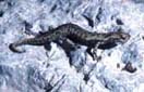
| Tenaya Lake, Yosemite National Park (elev. 8,150). 1,000 years ago, trees grew in then-dry Tenaya Lake. Today only their tops show: still rooted in as much as 70 feet of water. |
Trees
Rooted Under 70 Feet of Water?
The trail of evidence begins on the shores of Mono Lake at the eastern base
of the Yosemite Sierra. Because it has no outlet (and is therefore "hydrographically
closed"), this highly saline lake fluctuates widely, rising whenever
inflow exceeds evaporative loss, and falling during times when evaporation
wins out. Like glaciers themselves, themselves, the lake can accumulate mass,
greatly expanding during prolonged wet periods, while contracting during persistent
spells of dryness. By tracing the former rises and falls of Mono Lake, therefore,
it is possible to reconstruct a record of past water availability in the eastern
drainages of the central Sierra.
Hints of this record came as early as 1960, when D.B. Lawrence visited the Mono Basin. For over a decade prior to his visit the lake had been falling—not because of natural dryness, but because the Los Angeles Department of Water and Power (LADWP) had been diverting the tributary streams. Walking the southwestern shoreline (then at an elevation of 6400 feet), Lawrence discovered the rooted remains of long-dead trees, with up to fifty growth rings, that had only recently emerged from the declining lake. He reasoned that, to account for the presence of the stumps, the lake must have been lower than 6400 feet at some time in the past. Two years later, hydrologist Sidney Twitchel Harding sampled one of Lawrence’s trees for radiocarbon dating, and derived an age of 920 + 90 years BP (radiocarbon years before present). Lawrence and Harding thus concluded that the lake had remained below 6400 feet for a half-century or more around the last turn of the millennium.
When I began my doctoral research at Mono Lake in the early 1980s, LADWP’s diversions had drawn the shoreline down almost 30 additional feet, to a level of 6372 feet—roughly 50 feet below the lake’s "natural elevation". This additional drawdown had exposed thousands of acres of "new" shorelands. Protruding from these relicted lands were dozens more stumps—from Jeffrey pines (Pinus jeffreyi) and cottonwoods (Populus trichocarpa), as well as from shrubs like rabbitbrush (Chrsothamnus nauseosus) and big sagebrush (Artemisia tridentata). A substantial number of these rooted relicts stood very close to the artificially lowered shoreline, and several were actually still under water. With help from my colleagues Ken Lajoie and Steve Robinson at the United States Geological Survey (USGS), Tom Brown and Michaele Kashgarian at Lawrence-Livermore National Laboratory, and Wally Broecker and Guy Mathieu at Lamont-Doherty Earth Observatory of Columbia University in New York, I ultimately radiocarbon dated wood from 17 of the low-elevation stumps. These analyses segregated the derelicts into two distinct generations. Nine of the individuals were of an antiquity comparable to the Lawrence-Harding stump. Calibrations and averaging brought the "death date" of this generation (hereafter, the "Generation 1 stumps", or simply "G-1 stumps") to approximately AD 1100. But the other 8 individuals belonged to a younger generation, with a death date close to AD 1350 (hereafter, the "Generation 2" , or "G-2" stumps). As analyses of the lake’s deltas would later confirm, the Mono stumps were reflecting not just one Medieval lowstand, but two.
Given the elevation of the lake at the time of their visits, Lawrence and Harding could conclude that, during the decades prior to the death of their stump, climate must have been at least moderately dry relative to that of the 20th century. But the low-elevation stumps that emerged after 1960 told of much drier conditions—drier, in fact, than any of the multi-year dry spells apparent in the instrumental record, except perhaps one: the water years 1976 and 1977, when runoff in the Mono Basin averaged just 45 percent of the twentieth-century mean. Moreover, the two Medieval lowstands reflected not just a single strident drought, but rather a severe "double-drought".
How long did these Medieval droughts persist? And were they restricted to the Mono Basin, or did they encompass a much larger area? The answers to these questions began to emerge in the mid-1980s. On a drive across Highway 120 late in the fall of 1987 I stopped at Tenaya Lake with my canoe. As I had seen on many prior late-year trips, the tops of a dozen large tree trunks were protruding from the lake surface. With a 100-foot measuring tape at the bottom of the boat, I paddled to the protruding trunks and measured the depth of water at their bases. From the two individuals standing in the deepest water (nearly 70 feet!) I collected slivers of outermost wood for radiocarbon dating.
I reasoned that, if these trunks were actually rooted on the lake floor, they must have grown when the shoreline stood at least 70 feet below its modern elevation. Because the spillway of the lake has remained at the same height and location since the last withdrawal of glacial ice more than 14,000 years ago, any such lowstand must have been caused by drought.
The C14 analyses segregated two generations of Tenaya trunks—the first killed around AD 1100 (contemporaneous with Mono’s G-1 stumps), and the second killed approximately AD 1350 (contemporaneous with the G-2 stumps). Here, then, was evidence that seemed to corroborate the severe Medieval droughts inferred from Mono Lake. Moreover, a count of the annual rings in these two dated trunks indicated that the first of the Tenaya lowstands must have lasted at least 140 years, and the second at least a century. To an extent even greater than the Mono stumps, the Tenaya trunks indicated both severity and persistence of the Medieval droughts. Continued next page
Our Founder Questions? Go to About Our New Site |
Masthead
Photo from: |