|
|
|
2007
Report on Analysis of Water Quality of Lakes and Streams in Sequoia
and Kings Canyon National Parks
Robert W. Derlet, M.D.
Professor
University of California, Davis
 |
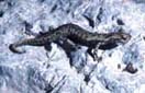
| Pristine Sierra lake near Mt. Whitney, Sequoia National Park. This lake receives almost no hiker use and no stock use. Note relative absense of algae on sandy bottom and smooth banks of meadow at stream edge. |
Surface water
quality in Sequoia and Kings Canyon National Parks is important for backcountry
users as well as downstream municipal water districts. It’s
water contributes in part to the Sierra Nevada Mountains watershed which
provides 50% of California’s fresh water for domestic use. Melting
snow must pass through a fragile ecosystem prior to runoff into lowland reservoirs. This
ecosystem, primarily granite or metamorphic rock has little buffering capacity,
and therefore small amounts of environmental pollution, may have a significant
impact on biotic life. Much of this watershed encompasses road less, back
country wilderness areas which have limited and restricted use. Over the
past 50 years, deposition of rate limiting substances by humans, and
domesticated animals and increases in air pollution from the central
valley have resulted in increasing eutrophication, and increases in phytoplankton
species and biomass. We hypothesize that this changing environment
may also affect the presence of total and pathogenic bacteria and algae biomass.
Therefore, identifying specific factors that are associated with increases
microorganisms and algae are important. Understanding factors that impact
the water quality from these areas is important for use restrictions and
management decisions.
Coliform bacteria have been established as indicators of fecal pollution
of watersheds. The findings of coliforms would indicate that the watershed
carries a risk for water-borne diseases such as entero-invasive E. coli, Giardia,
Salmonella, Campylobacter, Yersenia species and other
microbial pathogens, some of which can survive for extended periods in the
environment. The objective of the current study was to determine coliform
presence in Kings Canyon National Park backcountry, and study associated
indicators of human impact on water including total bacteria, algae biomass,
as well as other indicators of harmful pollution.
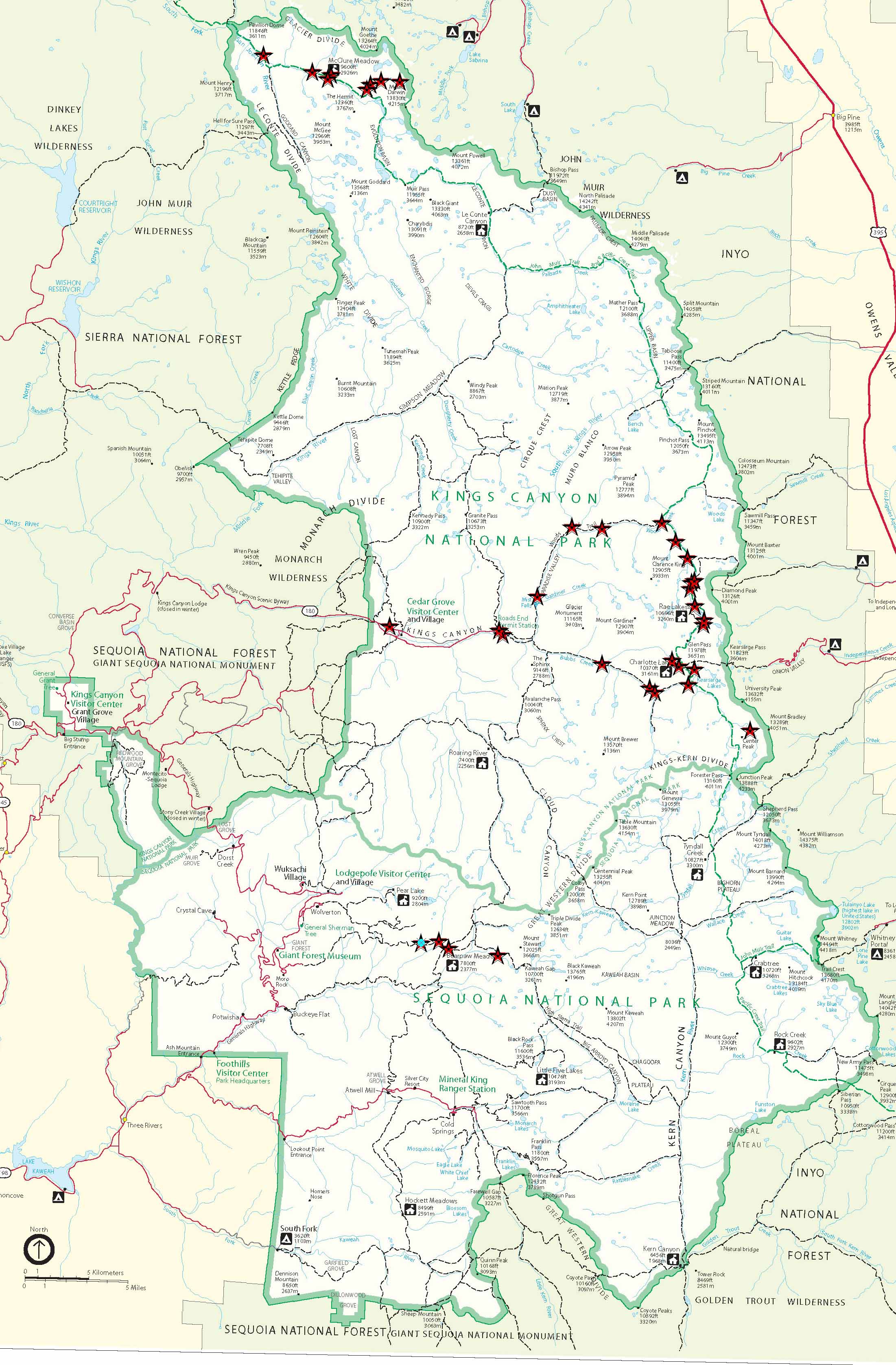 |
Sequoia and Kings Canyon National Parks: Dr. Rober Derlet, Water sample sites, 2007. (Click map to enlarge -- large file, not recommended for dial-up connections). |
METHODS
A total of 37 study sites in back country lakes and streams in Kings Canyon
National Park were analyzed during the summer of 2007. Analysis consisted
of observation comparisons of algae biomass, amount of non-organic stream
and lake foam, a quantitative assessment of heterotrophic bacteria, and
determination of the presence of coliforms. The following methods were
applied:
RESULTS
A total of 37 sites were analyzed as listed below, followed by the site Elevation
and Land use Risk category. The risk category abbreviations are: W = Wild/no
human impact areas; DH = Day Hike or pass through areas; BP = Backpack
areas; PA = Pack Animal areas. Note: These classifications are based
on site observations by the author, and do not necessisarily reflect data
or observations from the National Park Service.
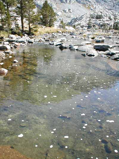 |
| Outlet of Evolution Lake, Kings Canyon National Park. Note algae growth on bottom and foam on surface. Both can be indicators of high visitor use and careless camping practices: washing body or dishes in or near water; feces from stock or human use washing into lake and increasing nitrogen/phosphorous load. |
Specific Positive Coliform sites by risk category
These
classifications are based on site observations by the author, and
do not necessisarily reflect data or observations from the National
Park Service:
Encouraging Findings: The side streams used by rangers at McClure and Rae Lakes Ranger Stations have been free of Coliforms for all the years studied. Anecdotally, I believe that the Wilderness Permit Ranger lectures are very important in maintaining the natural state of the backcountry and they are doing a great job. This year, I observed both McClure Meadow and an enlarged new portion of the Kings “Junction Meadow” as examples of successes in Meadow restoration which will be important to water quality.
DISCUSSION
Water year 2006-2007 was a dry year which may have affected results
with most watersheds receiving less than half normal precipitation.
The spring along the JMT between Glen Pass and Upper Rae Lakes was
dry as of September 1.
Algae:
Algae have become a significant problem in certain parts of the Park, and the drought year and lower water flows contributed to an additional algae biomass. In particular algae biomass is greatest in the Rae Lakes area from Dollar Lake upward to Lower Rae Lake. These areas are heavily used both by backpackers and stock.
Foam
Foam was also found in two areas heavily used by stock and backpackers, Dollar Lake and Bubbs Creek at Vidette Meadow. A surprise finding of foam in the Darwin Bench was unexpected. This suggested that this area which is considered lightly used and does not have a designated trail may have been impacted heavily by backpackers this summer.
Total Bacteria
Total heterotrophic bacteria correlated well with both Backpacker and Pack Animal use.
Coliforms
Data by risk category is consistent with prior studies in SEKI, as well as data from the entire Sierra which involves nearly 600 water samples which we have analyzed over the past six years. In general, water from Pack Animal areas have a high coliform prevalence. No significant difference in prevalence was noted despite the dry year. Some difficult to explain trends have been found over the past 6 years. East Lake creek at its confluence with Bubbs Ck has tested negative for 6 of 6 years despite moderate stock use in the watershed.
FUTURE STUDIES
Future studies need to be directed in a number of areas. This would include
more quantitative analysis of algae using chlorophyll extraction and analysis
techniques. In addition, analysis of foam by subjecting foam and water
from foam sources to multi-variant chemical analysis would helpful to determine
the possible sources. We believe excessive foam results from soaps, detergents,
cleaning agents or sunscreens used by backpackers. A specific study area
watershed could be created within the park that would help to further investigate
algae, foam, bacteria and coliforms. Such a study area would be selected
and the results compared with a similar area that did not have study area
restrictions. For example, the hypothetical Evolution Valley study area
could be compared to another area in the park over several years. Study
area restrictions could include prohibiting use of soaps or cleaning agents
in the area, preventing grazing which would minimalize stock use and prohibiting
camp fires above 9,600 ft which should decrease camp sites.
The high sierra are under ever increasing pressure from air pollution, backpackers, campers , and domestic animals used for transport or simply for grazing on public lands.. Although this report is based largely on carefully recorded observations over past summer, it is consistent with data from research from the past 6 summers. If only these are considered they represent clear evidence that there should be current and future concern for water quality derived from the higher elevations. Plans should now be developed to prevent future deterioration. Urgency exists, since the anticipated climate models we are expecting less rainfall and less snow at the higher elevations so that preserving the integrity of the forests, the ground cover and the standing and flowing waters becomes increasingly important.
RECOMMENDATIONS:
Expand protected meadow status. Because of the associated wetlands, McClure should have permanent protection from grazing. Consider adding Colby Meadow, and also Big Pete in the LeConte drainage to a list of permanent protected meadows
Require backpackers to take lightweight collapsible buckets to encourage washing away from streams or lakes.
Require stock riders to rake and cover manure at lease 100 ft from streams or lakes.
For Further Reading
2006
Report on Analysis of Lakes and Streams in Kings Canyon National
Park for Coliform Bacteria and other Microorganisms
Robert W. Derlet, M.D.
High
Sierra Water: What is in the H20?
Robert
W. Derlet, MD
Professor of Medicine
School of Medicine
U.C. Davis
Kemal
Ger
Department of Environmental Science
University of California, Davis
An
Analysis of Human Pathogens Found in Horse/Mule Manure Along the
John Muir Trail in Kings Canyon and Sequoia and Yosemite National
Parks
Robert Wayne Derlet, MD James Reynolds Carlson, PhD
From
the Emergency Department (Dr Derlet) and the Clinical Microbiology
Laboratory (Dr Carlson), University of California, Davis,
Medical Center, Sacramento, CA
A
Walk Through the Hydroclimate Network in Yosemite National Park: River
Chemistry
Dave Peterson, Rich Smith, Steve Hager
United States Geological Survey
Airborne
Pollutants in National Parks: Sequoia Park joins Large Study Effort
Judy Rocchio
Air Quality Program Coordinator
Pacific West Region
National Park Service
Giardia
Lamblia and
Giardiasis
With Particular Attention to the Sierra Nevada
by Robert L. Rockwell, PhD
Our Founder Questions? Go to About Our New Site |
Masthead
Photo from: |