|
|
|
Sierra Nature Notes, Volume 1, May 2001
Continued
from: The Great Droughts of Y1K
by Scott Stine, Ph.D
California State University, Hayward
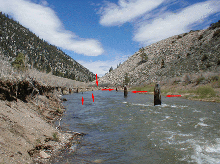 |
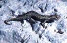
| West Walker River, Chris Flat (elev. 6,500 ft.). Relict stumps dated to two severe droughts ending about AD 1100 and AD 1350 (G-1 & G-2 stumps). |
West
Walker River, Eastern Sierra
Further corroboration came in 1990 during a November drive along Highway 395.
Roughly 3 miles north of its junction with Highway 108 (the Sonora Pass road),
395 enters the narrow-bottomed West Walker River Canyon. With water levels
low during this dry season of a dry year, relict stumps—short in stature
but large in diameter—could be seen rooted in the West Walker River.
This initial sighting involved four specimens, all Jeffrey pines, located
approximately 0.4 miles downstream of the canon head. With sunlight fading,
I was able to collect wood from just one of the relicts for later radiocarbon
dating.
According to Professor Andrew Leiser of University of California at Davis, Jeffrey pines can tolerate complete inundation of their root systems for only short periods—perhaps two weeks or less—during the growing season. Given the narrowness of the canyon bottom, it therefore seemed implausible that these trees, rooted in the lowest areas of the canyon floor, could have coexisted with a stream the size of the modern West Walker River. It appeared likely that, for one reason or another, the stream must have been far smaller than today throughout the life of these trees. Because piracy of the West Walker River by some other stream could be ruled out, drought seemed the most reasonable explanation for past diminution of stream flow. The radiocarbon date confirmed this proposition: Like the G-1 stumps at Mono and Tenaya, the one dated individual from the West Walker River grew during the first of the Medieval droughts.
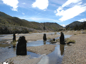 |
| G-1 and G-2 stumps, West Walker River. Sierra Crest in distant background. |
The following spring I returned to the canyon to seek out and sample more rooted stumps. I found a total of 33 (all Jeffrey pines, all rooted low on the canyon floor), most of which were near Chris Flat, downstream of the initial sightings. More radiocarbon analyses indicated that the West Walker stumps divided roughly evenly between those that grew during the first of the Medieval droughts (when stream levels were low enough to permit tree colonization and growth), and those that grew during the second drought (when conditions on the canyon bottom again favored establishment and growth of trees).
After debouching from its canyon, the west fork of the Walker flows north and eastward, joining the slightly smaller East Walker River near the town of Yerington, Nevada; the combined flow then bends south and enters Walker Lake. If its main feeder stream (the West Walker) was indeed low during Medieval time, as the canyon stumps would seem to indicate, then Walker Lake itself must have dropped to a low level as well. This hydrographically closed lake of western Nevada thus represents a place to "test" the drought hypothesis.
Regional
Droughts Confirmed
How to conduct such a test? Throughout the past 130 years Walker Lake has
been artificially impacted to an even greater extent than Mono Lake. Deprived
of much of its natural inflow by agricultural diversions in the Smith Valley,
the lake’s surface has stood as much as 140 feet below its natural level
since the late 1960s. In 1969 hydrologist Marty Mifflin of the University
of Nevada was walking the southern shore of the lake with friends when he
found a large stump rooted near the greatly depressed shoreline. Some years
later he dated wood from that relict and derived an age comparable to the
G-1 stumps from Mono, Tenaya, and the West Walker River. Thus, as I learned
in 1993, the "test" that I sought had already been performed, and
it affirmed the drought hypothesis.
Then came evidence from Owens Lake indicating that severe Medieval drought had extended into the southernmost reaches of the Sierra. In reconstructing the prehistoric fluctuations of this hydrographically closed lake in the early 1990s for the Far Western Archeological Research Group of Davis, California, I encountered indications in the deltas on Ash and Cottonwood creeks that lake levels had been low during at least the first of the Medieval dry spells. Evidence that the lake had actually desiccated during the Medieval period came two years later, when Mr. Rod Schmidt of Lone Pine guided me around areas of quicksand onto the Owens Playa (the lake has been reduced to a playa during much of the 20th century due to water diversions by the LADWP). Rod had seen scatterings of archeological materials at several places on the playa, indicating that early human inhabitants had wandered the dry surface at some time (or times) in the past, probably to exploit small residual marshes. Our immediate objective was to map and date these artifacts. The search turned up not only archeological materials (some of them at very low elevations on the playa), but rooted, tufa-encrusted shrub stumps as well. Archeologist Robert Bettinger of U.C. Davis identified the artifacts from photographs as being of the "Rose Spring type", a type produced by inhabitants of the western Great Basin between roughly AD 650 and 1350. While this archeology spoke in general terms about the timing of prehistoric desiccation of the lake, the shrub stump provided a more specific date: radiometric analysis indicated that it comported in age with the G-1 stumps from all the sites to the north.
Since the early 1990s much has happened to further clarify the nature, timing, and extent of the Medieval droughts in the Sierra. In January of 1997 the West Walker River rose to record levels, greatly widening its channel along much of the canyon. The flood exposed many rooted stumps (including several large cedars—Calocedrus decurrens) that had previously been obscured, thus confirming their widespread distribution across the canyon floor. Presently 104 rooted stumps are visible between the upper end of the canyon and the lower end of Chris Flat. Tom Brown and I have thus far run radiocarbon assays on 38 of these individuals, all but two of which date from the Medieval drought terminations.
Meanwhile, several workers have been active in the more northerly areas of the Sierra. Palynologist Dave Adam, formerly of the USGS, reports that Osgood Swamp, a large marshland (elevation ~6500 feet) located between Lake Tahoe and Echo Lake, contains rooted remains of lodgepole pines, similar in age to the G-1 specimens, that could have grown only if the marsh desiccated; archeologist Susan Lindstrom, while diving in Independence Lake north of Tahoe, discovered stumps comparable to G-2 in age, rooted in deep water on the lake floor; and most recently divers Phil Catarino and Eric Henningsen have discovered the trunks of large trees of G-1 age rooted on the floor of Fallen Leaf Lake, immediately south of Lake Tahoe; they have also dived Tenaya Lake and are able to confirm that the Tenaya trunks are rooted in growth position. Further exploration will undoubtedly turn up still more lakes, rivers, and marshes whose water levels were drawn down by drought during Medieval time; moreover, with further exploration, some of the sites that have thus far yielded evidence of only one of the two Medieval droughts will likely produce evidence of the other.
The
Next Drought?
One may reasonably ask why these droughts occurred. The simple answer lies
in the wintertime configuration of the "storm track" (a.k.a. the
"jet stream" and the "polar front") over the northeastern
Pacific. When the storm track persists over California for much of the winter
(as it did, say, in 1982, ‘83, 86, and ‘96), many Pacific cyclones
are steered over the state, and we accumulate much precipitation. When the
track lies to the north of California, the fronts are steered away, and the
region remains dry. This latter case prevailed during the 1976-77—the
one period of our instrumental record dry enough to provide an analog to the
Medieval droughts. Nineteen seventy-seven, it turns out, was not only the
driest winter on record over much of California, it was also the wettest winter
on record over much of Alaska. Simply put, rather than the storm track bowing
south over California, in 1976-77 it bowed north over Alaska, and held there.
Evidence is now emerging that the "dry-winter-in-California, wet-winter-in-Alaska" model holds true not only for 1976-77, but for much of upper Medieval time as well. In Alaska, as in most other areas of the world, glaciers are now melting back rapidly in response to global warming. As the ice streams around Prince William Sound recede, geologist Greg Wiles and his co-workers are discovering newly exposed stumps, rooted in place on the recently deglaciated canyon floors, that were sheared off near their bases when the glaciers last advanced. Radiocarbon dates on the stumps indicate that they died (and that the glaciers therefore advanced) between AD 900 and 1300—the very time when California was in deep drought. Importantly, these south-Alaskan glaciers—the Princeton, Sunlight, McCarty, Northwestern, Aialik, Sheridan, and Stellar—are known from monitoring to advance in response to wet winters. These glaciers, and the sheared stumps persisting from their last advance, therefore indicate that while California was experiencing profound drought during the centuries straddling the last millennial turn, Alaskan winters were abnormally wet.
Evidence too detailed to discuss here indicates that the Medieval droughts of the Sierra were the most severe of the past 4000 to 7000 years. This is not to say, however, that other dry spells are absent from the record. Persistent droughts, moderate by Medieval standards but strident relative to our "normal" conditions of the past 150 years, drew lakes and rivers well below their modern levels on numerous occasions during the past two millennia, most recently during the late 18th and early 19th centuries. Indeed, increasing evidence indicates that there is little that is climatically "normal" about the past century - and- a-half; it appears, in fact, to be California’s third- or fourth-wettest century-scale period of the past four or more millennia.
Since statehood, Californians have been living in the best of climatic times. And we’ve taken advantage of these best of times by building the most colossal urban and agricultural infrastructure in the entire world, all dependent on huge amounts of water, and all based on the assumption that runoff from the Sierra Nevada will continue as it has during the past 150 years. Yet even in these best of times we have run out of surplus water, and we fight over allocation.
Drier times undoubtedly lie ahead.These may be anthropogenically induced, as we turn our atmosphere into an artifact. But with or without human inducement, episodic droughts, severe and persistent, will return, just as they have in the past. Such drought will take a severe toll on our infrastructures and institutions.
But severe and persistent drought will also take a severe toll on what remains of our wildlands. The paleodroughts of the Sierra and surrounding regions undoubtedly inflicted much stress on plants and animals. Aquatic, amphibious, and riparian species were likely hit especially hard, as lakes and streams shrank, marshes and wet meadows desiccated, and spring sites diminished in size and number. Clearly, the indigenous species that we see today in the Sierra survived these past droughts, and ultimately may have been invigorated by them. But could these same plants and animals, so artificially stressed and constricted today, survive epic drought again? They will, but only if our society takes the long view, preserving during the best of times, preparing for the worst of times.
Our Founder Questions? Go to About Our New Site |
Masthead
Photo from: |