|
|
|
For most Californians, the critical number for understanding their water supply is what the winter's snow pack in the Sierra Nevada looks like. Snow that falls in the Sierra between November and April supplies almost half of the drinking, agricultural and recreational water for all of Californian. If you live in, say, San Francisco or Los Angeles, your local rainfall totals could be 120% of normal, but if the Sierra only reached 70%, you could well be looking at water rationing and higher prices for produce at the market.
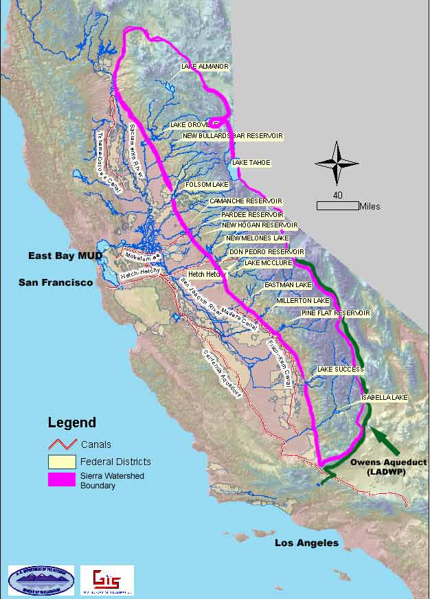 |
| From
the Sierra to your house: California's extensive dam and aqueduct system,
much of it fed by the Sierra Nevada watershed. Adapted from Bureau of Reclamation map (Click to enlarge). |
The Sierra
Reservoir
Beginning in October, moisture-laden storms come off the Pacific ocean. Tracking
west, the clouds are forced up against the Sierra, which forms a solid barrier
about 8,000 feet high in the north and over 14,000 feet in the south of the
range. This mountain barrier forces the clouds to rise, cooling as they do
so.. As you may remember from 7th grade science class, air as it cools condenses
forcing the moisture to fall out as rain or, above about 5,000 feet, snow.
Seasonal snow totals may only be two to three feet at the 5,000 foot elevation,
but increase rapidly at higher elevations, where as much as thirty-four feet
of snow can accumulate at 7,000 foot Donner Summit.
As spring and warming temperatures arrive, the snow begins it's journey to your water tap. In the northern Sierra, snow melts into small rivulets and streams which join ever larger rivers to feed the Feather, Yuba, Bear and American Rivers, flowing at last into the Sacramento River. In the southern Sierra, the San Joaquin River gathers runoff from the Mokulumne, Calaveras, Stanislaus, Merced (from Yosemite Valley), and Tuolumne Rivers. These two great rivers feed into a complex of delta channels that finally deliver the water into San Francisco Bay and the Pacific Ocean. Between the snow in the Sierra and the San Francisco Bay, though, are a complex of dams, diversions and aqueducts to transport much of this water throughout the state. Over 30 million acre-feet of annual runoff comes out of the Sacramento and San Joaquin valleys.
 |
|
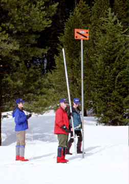
Measuring
the snowpack: surveyors beginning a snow course. The data will be used
to predict spring water runoff. |
In addition to the dams and aqueducts, there are hundreds of instruments in remote locations throughout the Sierra that automatically measure how much moisture falls in a storm, how much water remains in the snowpack, temperature, and what the stream flows are. In addition to the instruments, skiers with the California Department of Water Resources (CDWR) make monthly trips throughout the Sierra measuring and weighing the snow.
This data is used by state and federal agencies to predict how much water will be available for drinking, agriculture, recreation as well as the ecological requirements of rivers and wetlands. In the 150 years of Euro-American settlement in California, an incredibly complex web of water agreements have grown to claim the runoff of the Sierra. In the last two decades, legislation and court decisions have additionally required that the needs of river ecosystems and the San Francisco Bay delta be considered when allotting water.
Beginning in the early 1900s, major water projects began capturing and distributing the Sierra's water.
Los Angeles
Aqueduct
From Yosemite south, the Sierra crest averages over 12,000 feet high. Most
of the rain and snow from Pacific storms is wrung out on the west side of
the range, making most of the country east of the Sierra a desert for hundreds
of miles. This effect is called a rain shadow. From the crest, the mountains
drop suddenly into the high desert basins only a few miles away. Twenty miles
from the crest, the White and Inyo Mountains parallel the Sierra Nevada and
rise almost as high. Between these two massive ranges is the 90 mile long
trough of the Owens Valley. Sierra snow melt once flowed into the Owens River,
running the length of the valley to spread into Owens Lake. Farther north,
five smaller streams east of Yosemite fed Sierra runoff into Mono Lake.
Early in the century, the City of Los Angeles acquired water rights to 300,000 acres in the Owens Valley – about 98 percent of all privately-held lands. By 1913, an aqueduct was completed down the eastern escarpment of the Sierra capturing the streams flowing into the Owens River and diverting them to Los Angeles. In 1941, Los Angeles extended that aqueduct north and added the streams that would otherwise have gone to Mono Lake.
About 400,000 acre-feet of Owens Valley and Mono Basin water flows to Los Angeles each year. In 1978, a law suit by the Mono Lake Committee, National Audubon Society and others challenged Los Angeles' diversion of this water, claiming that fish, riparian habitat and Mono Lake's ecosystem were not considered when the diversions began. After a decade long legal battle the courts agreed. In 1994, the last of a series of favorable judgments for the Mono Lake Committee ordered Los Angeles to increase water flow into Mono Lake as well as begin restoration of the stream habitat destroyed since the aqueduct was built.
San Francisco
Bay Projects
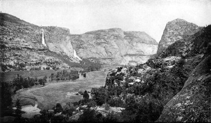 |
| Yosemite's Hetch Hetchy Valley, 1908. |
The damming and diversion of the Mokulumne (originating in the central Sierra,
south of Tahoe) and Tuolumne Rivers (from Yosemite) was part of the San Francisco
Bay Area's effort to keep pace, early in the century, with Los Angeles' water-driven
growth.
The City of San Francisco has been importing Tuolumne River water from Yosemite's Hetch Hetchy valley since 1923. That water choice had its beginnings early in the century and was one of the nation's first great conservation battles.
At the turn of the century, San Francisco looked at possible water sources for a rapidly growing city. The Tuolumne River has it's origins along the crest of the Sierra in Yosemite National Park. While still within the boundaries of Yosemite, it flows through the Hetch Hetchy Valley, a deep, glacially carved canyon the equivalent of Yosemite Valley. In the early 1900's, though, not many people had visited that part of the park and so it had few defenders. When a dam was proposed by San Francisco, legendary preservationist John Muir, who was intimately familiar with Hetch Hetchy, led the opposition.
 |
|
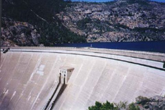
O'Shaughnessy
Dam, responsible for Hetch Hetchy Reservoir, located on the Tuolumne
River in Hetch Hetchy Valley. The reservoir is supplied primarily by
snowmelt from a watershed of 459 square miles located entirely within
Yosemite National Park. |
"Dam Hetch Hetchy?" John Muir declared during 1913 Congressional hearings, "As well dam for water tanks the people's cathedrals and churches, for no holier temple has ever been consecrated by the heart of man." One of Muir's arguments was that there were other rivers available to San Francisco (the Mokulumne River, for one, which would be developed soon after for the East Bay cities). But San Francisco coveted the Tuolumne because it was free of established water rights claims and would be the cheapest to acquire. In 1913, San Francisco did win that battle for the water but Muir's fight sparked the beginning of a strong preservationist movement which continues to this day.
By 1930, the Mokulumne River as well had been "captured" by East Bay Municipal Utility District. An aqueduct now carries water from Pardee Reservoir south of the Sierra foothill town of Jackson. Today EBMUD uses both the Mokulumne's and some of the American River's water to supply it's 1.2 million customers in Oakland, Berkeley and other East Bay California cities.
Central Valley
Project
In the southernmost portion of the Central Valley, a few rivers never reached
the sea. The Kern River once terminated in Buena Vista Lake. The Tule, Kings,
and Kaweah Rivers (from the Sequoia National Park area) once formed Tulare
Lake. Both Tulare and Buena Vista lakes are gone from today's California maps,
their river sources diverted for irrigation and their dry lakebeds transformed
into farm fields.
President Franklin D. Roosevelt signed an emergency relief measure in 1935, authorizing the Central Valley Project (CVP). Friant Dam, on the San Joaquin River, was completed in 1944; Shasta Dam, on the Sacramento River, in 1945; the canal system to deliver irrigation water from Shasta Dam to the San Joaquin valley opened in 1951.
The completed CVP eventually added major dams on the Trinity, American, and Stanislaus Rivers, ultimately totaling twenty reservoirs, eleven power plants, and three fish hatcheries. The CVP delivers seven million acre-feet of water every year to three million acres of farmland.
State Water
Project
Finally, the California State Water Project was the last of California's major
water projects to be completed. It is huge. Today, the Project includes 32
storage facilities, reservoirs and lakes; 17 pumping plants; 3 pumping-generating
plants; 5 hydroelectric power plants; and about 660 miles of open canals and
pipelines. It provides supplemental water to approximately 20 million Californians
and about 660,000 acres of irrigated farmland.
A Growing
Population, a Finite Water Supply
California's present population of 34.5 million is expected to climb to 47.5
million by 2020. Today, every suitable site for a major dam has been developed
in the Sierra Nevada river canyons. Rivers have been transformed into reservoirs,
with much of their water now traveling through irrigation ditches and city
pipes, rather than along wetland corridors to coastal estuaries and out to
the sea. Such shifting of water across California to serve human needs has
consequences at each end of the pipe. Plants and animals that are equally
dependent on water have had to settle for whatever people were willing to
share with the environment. Most of California's wetlands and river canyons
and many of its native species have been diminished or exterminated in the
face of that competition.
Although California's
water supply is still adequate for a "normal" water year, it takes
only a couple of drought years, such as we experienced in the extreme years
of 1977 and 1978 and the lesser drought of 1987-1992, to stretch our resources
to the limit and bring water rationing for both agriculture and drinking water.
A drought such as the one that
occurred in California and the west only 1,000 years ago would be catastrophic
to both the economy and ecology of California.
Though water is the essential molecule that supports life on Earth, it can be taken for granted as the distribution system quietly works behind the scenes. It is only during periods of drought or flooding that we are made aware of the plumbing involved. Whenever a new subdivision is built in Southern California or the San Francisco Bay Area, will its developers or the families that move into those houses appreciate their connections to Sierra Nevada habitats hundreds of miles away? Consider how difficult it is for someone in Los Angeles – at the far end of the pipe – to understand how a few gallons of water thoughtlessly wasted – or carefully conserved – each day can effect populations of birds on Mono Lake, 350 miles away. Our intricate "water web" means that 34 million Californians are closely connected to each other through their water pipes, but also to the natural environment that is the ultimate source of water for all life in this state.
Further Reading:
Cadillac
Desert : The American West and Its Disappearing Water
by Marc Reisner
The classic study of the history of water in California and the west. Can
also be seen as a 4 part PBS documentary.
California
State Water Project
California
Department of Water Resources, Division of Planning and Local Assistance
Sierra
Club Hetch Hetchy Restoration Task Force
Our Founder Questions? Go to About Our New Site |
Masthead
Photo from: |