|
|
|
Sierra Nature Notes, Volume 7, May 2007
Twentieth
Century Glacier Change in the
Sierra Nevada, California
Hassan
Basagic
Graduate Student
Geography Department
Portland State University
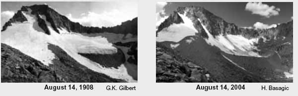 |
| Darwin Glacier, Kings Canyon National Park. This image illustrates glacier change in the Sierra Nevada. The image at left was taken on August 14, 1908 by G.K. Gilbert. The other was taken on August 2, 2003 by Hassan Basagic. |
Glaciers of the Sierra Nevada
The Sierra Nevada extend over 400 miles forming a mountainous spine along eastern
California. The beautiful alpine landscapes of the High Sierra owe much of
their existence to the work of glaciers that have sculpted the bedrock through
time. Within the southern and central regions of the Sierra Nevada, small
glaciers are still at work, slowly eroding the high peaks and ridges, and
depositing rock material below. The Sierra Nevada glacier population consists
of approximately 498 ice features, including perennial ice patches and mountain
glaciers (Raub et al., 1980). These features are small in size ranging from
small ice patches with areas of less than 0.1 km2, to Palisade Glacier, the
largest in the Sierra Nevada with an area of 1.58 km2 (Raub et al. 1980).
These glaciers are remnants from a cool period in the climate referred to
as the Little Ice Age (Matthes, 1940; Porter, 1981). Climatic cooling began
around 1350 AD, during which time glaciers began to form and advance. This
cool period persisted roughly through 1850 AD, at which time Sierra Nevada
glaciers are thought to have reached their maximum extent for the Little
Ice Age. Since that time, mountain glaciers throughout the world have showed
signs of overall recession during the past century.
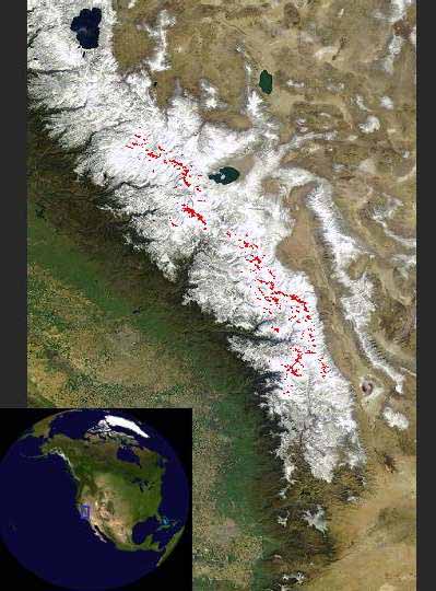 |
| The central
and southern Sierra Nevada with glaciers highlighted in red to show modern
extent. (MODIS image) |
Glaciers and Climate
Alpine glaciers are recognized as indicators of climate change because they
change in mass and geometry in response to climatic changes (Meier, 1965).
The link between changes in climate and glacier geometry is complex and indirect.
The meteorological environment determines accumulation and ablation at a
glacier, on which a glacier’s mass is dependent. A change in mass produces
a dynamic response within a glacier that causes changes in glacier geometry.
Observations in glacier geometry through time can therefore provide an indication
of long-term climatic variations and environmental change in alpine areas.
Sierra Nevada climate is complicated by local topographic variables that can
exert a degree of control over regional climate. These variables include elevation,
aspect, and slope. Alpine landforms such cirque headwalls and ridges can modify
local climate by reducing incoming solar radiation through shading, reducing
local temperatures, and altering or intensifying wind patterns. Glaciers in
the Sierra Nevada typically exist in north and northeast facing cirques as
these location receive less incoming solar radiation.
 |
The
view from Mount Darwin looking south toward Evolution Valley. Snow
and ice remain in north and northeast cirques that are protected from
incoming solar radiation. |
Research
The
purpose of my research is to quantify the rate and magnitude of change
glacier extent over the past century in Sierra Nevada. A reduction in Sierra
Nevada glaciers can be assessed by comparing photography of glaciers taken
over the past century (see above and below). While knowledge of glacier shrinkage
is common, there is little quantitative information on the magnitude
or the rate of this reduction. I specifically propose to:
I am compiling previous extents of several glaciers using terrestrial and
aerial photographs and mapping these changes in a Geographic Information
System (GIS). Repeat photography will serve as a visual comparison
and aid mapping efforts. The start date roughly follows the maximum
of the Little Ice Age in the Sierra Nevada.
Sierra Nevada Glacier Photographs
Here is a comparison of a photo of Yosemite's Lyell Glacier, taken in 2003
by Hassan Basagic, to one taken in 1903:
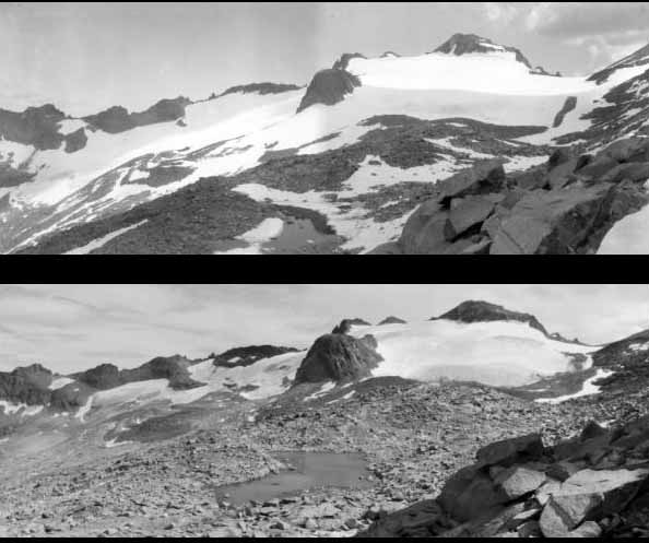 |
| A comparison of Lyell Glacier, Yosemite National Park in 1903 (top) taken by G.K. Gilbert, and 2003 (bottom) taken by Hassan Basagic. |
Preliminary Results
Comparisons
of the repeat photography reveal that all ten glaciers surveyed in 2003 and
2004 have experienced a reduction in ice volume and surface extent over the
past century. Repeat photography is a valuable tool in determining change
through time, especially when combined with aerial photos and field measurements.
A case example at Lyell Glacier indicates the surface area of the west lobe
has been reduced by 31% since 1900, and the smaller east lobe has been reduced
by 79%. These results support the idea that topographic controls strongly
influence individual glacier response to regional and global climate change.
References
Matthes,
F.E., 1940. Committee on glaciers, 1939-1940. Transaction, American Geophysical
Union: 396-406.
Meier, M.F., 1965. Glaciers and climate. In: H.a.F.D. Wright (Editor), The quaternary of the United States. Princeton University Press, Princeton, N.J.
Porter, S.C., 1981. Glaciological evidence of Holocene climatic change. In: T.M.L. Wigley, Ingram, M.J. and Fermer, C. (Editor), Climate and History. Cambridge University Press, Cambridge.
Raub, W.B., Post, A., Brown, C.S. and Meier, M.F., 1980. Perennial ice masses of the Sierra Nevada, California, World glacier inventory. IASH-AISH Publication 126: 33-34
Questions
or comments? please contact me: Hassan
Basagic
Further Reading
Hassan Basagic's Homepage
Glacier Research, Portland State University
Glaciers
of the American West
Sierra
Nevada Climate:
1650–1850
Our Founder Questions? Go to About Our New Site |
Masthead
Photo from: |