|
|
|
Sierra Nature Notes, Volume 3, March 2003
Yosemite
Falls—A New Perspective
By N. King Huber
Geologist Emeritus with the U. S. Geological
Survey.
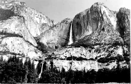 |
| Figure 1. Upper Yosemite Fall now leaps from the hanging valley of Yosemite Creek. In the not-too-distant geologic past its water cascaded down through the prominent ravine immediately to the west (left). (click to enlarge) |
Yosemite Falls with their spectacular drop of 2,425 feet (including the Upper Fall, middle cascades, and Lower Fall) are world-renowned and an icon for Yosemite Valley (Fig. 1). They are truly unmatched and were recognized as such early on.
In 1851,
the first descent into Yosemite Valley by non-Indians was made by the
Mariposa
Battalion under the command of Major James Savage. Lafayette
Bunnell, who had served as a medical aide during the Mexican War and
was called “Doc” by his colleagues, was one of the literate
members among the rough frontiersmen making up the group. He was greatly
impressed by the valley, and around the evening campfire proposed the
Indian name “Yo-sem-i-ty” for both the valley and the falls.
Bunnell later recorded his impressions of the valley's scenic wonders
in glowing terms. With respect to Yosemite Falls he noted that: “comparison
of the Yosemite Falls with those known in other parts of the world, will
show that in elements of picturesque beauty, height, volume, color and
majestic surroundings, the Yosemite has no rival upon earth.”1
James Mason Hutchings, an early promoter of Yosemite, organized the
first party of sightseers to enter Yosemite Valley in 1855. Later that
same year he published a lithograph based on a drawing of Yosemite
Falls made at the time by Thomas Ayres, and thus introduced these spectacular
cascades to the world for the first time (Fig. 2).
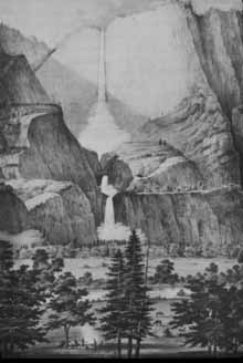 |
| Figure 2. This "Yo-hamite or Great Falls" drawing by Ayres was then made into a lithographed poster by Hutchings in October, 1855, which was the first artistic representation of Yosemite Falls to reach the public. (YNP Archives). |
In his monumental study of Yosemite Valley, François Matthes wrote: “Surpassing all the other falls [of the valley] in height and splendor are the Yosemite Falls,” and “they are easily [the valley's] most spectacular scenic feature. Even more than El Capitan and Half Dome they have given the Yosemite its wide renown.”2 But beyond their scenic impact, recognized by all, is the story of the falls' possible origin—one that is both fascinating and somewhat surprising.
Waterfalls cascading down a valley's walls from far above its floor have long been considered as evidence of a glacial origin for that valley. Indeed, little doubt exists that Yosemite Valley represents a profound glacially-driven modification of the pre-glacial Merced River canyon, because no other erosive agent could have accomplished such excavation. An ancient glacier that filled the valley to its present rim created the basic broad shape of the valley and gouged out a deep bedrock basin whose bottom locally lies more than 1,000 feet below the present valley floor.
The valley-forming glacial episode was named the “El Portal” glaciation by François Matthes in his Yosemite study, because he estimated that the El Portal glacier advanced down the Merced River canyon to the vicinity of the community of El Portal, some 10 miles downstream from Yosemite Valley proper. Today, most geologists would correlate that glaciation with the “Sherwin” glaciation, defined from studies along the east side of the Sierra Nevada. The Sherwin was the most extensive and longest-lived glaciation documented in the eastern Sierra. It may have lasted 300 thousand years and ended about 1 million years ago.3
The enormous Sherwin-age glacier that shaped Yosemite Valley was fed from an ice-field in the High Sierra, and was able to excavate the central chasm to a greater depth than smaller glaciers could erode in their side-entering tributary channels. When the ice left, some of the side valleys were left "hanging" with waterfalls at their confluence with the main valley. Since Sherwin time, most of the tributaries have eroded their channels back into the walls to leave little more than steep ravines with minor falls interrupted by chains of cascades, such as those at Sentinel Fall. Free-falling Bridalveil Fall is an exception, although it also has receded back into an alcove from its original position on the valley wall.
Later glaciations in the Sierra Nevada were of lesser area and apparently briefer than the Sherwin, but their actual number is uncertain. Matthes did recognize evidence for younger glacial activity, and he mapped the extent of what he called the “Wisconsin” glaciation, a name derived from the last glacial epoch in the northern mid-continent region of the United States. In the Sierra, his Wisconsin includes both the now-recognized “Tahoe” and “Tioga” glaciations, which probably peaked about 130,000 and 20,000 years ago, respectively. Much smaller than those of the Sherwin, glaciers of these later episodes did not come close to filling Yosemite Valley and thus did little to further modify or smooth its walls.
The sequence of post-Sherwin glaciations, however, probably contributed to the forming of the Upper Yosemite Fall that we know today. The fall leaps from its hanging valley now, but as we will see, it has a more complex history than its neighbor falls, such as Bridalveil Fall.
Yosemite Creek is the largest stream flowing into the north side of Yosemite Valley and probably entered the pre-glacial Merced River canyon through a steep side ravine. Even after the Sherwin glacier excavated Yosemite Valley, Yosemite Creek continued to enter the main valley through that ravine, which lies just west of the site of the present Upper Fall (Fig. 1). At that time, the site of the present fall was fed by a very small drainage area between Yosemite and Indian Canyon Creeks and probably hosted only a minor ephemeral fall of short duration during spring runoff.
John Muir
was impressed by the steep ravine, but did not recognize its pre-glacial
existence
when he noted that: “there is a very deep
cañon on the left of Yosemite falls. . . & I could not account
for its formation in any other way than by supposing the existence of
a glacier in the basin above.”4 More importantly, Muir
noted that Yosemite Creek is anomalous in that above the present Upper
Fall it “is
rather level”: “and to the levelness . . . of this one, we in
a great measure owe the present height of the Yosemite Falls. Yosemite
Creek lives the most tranquil
life of all the large streams that leap into the valley, the others,
. . . while yet far from the valley, abound in loud falls and snowy cascades,
but Yosemite Creek flows straight on through smooth meadows and hollows
. . . biding its time . . . for the one anthem at the Yosemite. . .”5
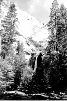
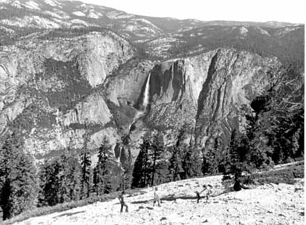 |
| Figure
3. John Muir noted that, unlike other large streams entering
Yosemite Valley, Yosemite Creek flows across a rolling upland,
descending
gradually with a low stream gradient before cascading over the
Upper Fall. Photo by Richard Frear, NPS Collection. (click to enlarge) |
It would appear that John Muir was the first to observe that Yosemite Creek was unique because it leaped out over the brink of Yosemite Valley (Fig. 3) and was not ensconced in a “cañon,” as were all of the other large streams entering the valley, including Bridalveil Creek.
In his Yosemite
study, François Matthes concluded:
“That the broadly open notch west of the Upper Yosemite Fall was once
the path of a stream flowing along the western margin of the [Yosemite
Creek] glacier can hardly be doubted, for what appears to be an old stream
channel leading to the notch is traceable along the west side of the
[present] hanging valley for a quarter of a mile [Fig. 4], and 1,600
feet below the brink, at the foot of the incline on which the zigzag
trail is built, there appears from beneath the débris a deeply
cut stream channel, now dry, that joins the gorge of Yosemite Creek a
short distance above the lower fall.”6
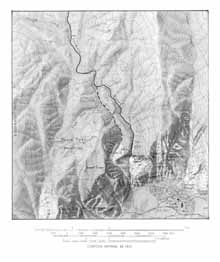 |
| Figure 4. Yosemite Creek now and then. Today Yosemite Creek (heavy solid line) flows over the valley rim to create Upper Yosemite Fall. Before its postulated diversion, perhaps little more than 130,000 years ago, Yosemite Creek flowed down an older channel just to the west (heavy dashed line), from which it cascaded down through the steep ravine that is now the route of the Yosemite Falls Trail (click to enlarge). |
The trail leading north above the head of the notch continues to follow the old Yosemite Creek channel a little more than one-half mile to the junction with the present stream channel.
Much of the old stream channel in the steep ravine below the notch has been filled by rockfall since it was abandoned. However, the deep cut of the old channel mentioned by Matthes just above the Lower Fall is so pronounced that it shows clearly on the topographic map and was probably responsible for a small waterfall now present in the middle cascades. The site of this old channel, although largely obscured by vegetation, can be seen from below the Lower Fall (Fig. 5). It also can be seen from the Yosemite Falls Trail near where the trail turns upward into the actual ravine.
The presence of this lower ancient channel is critical to our interpretation of Yosemite Creek's history. It is lower in elevation than, or well below, the probable valley bottom of the pre-existing Merced River canyon prior to glacial deepening. It, therefore, likely continued to be the active channel for Yosemite Creek even after Yosemite Valley was glacially excavated a million years ago.
 |
| Figure 5. View of Lower Yosemite Fall with site of ancient channel descending from upper left down through vegetated area. |
Matthes did not speculate on how or when Yosemite Creek was diverted from that old channel into its present channel to create Upper Yosemite Fall. He did, however, map a complex of glacial moraines, a series of arcuate ridges crossing the drainage above the valley rim (Fig. 6). These moraines consist of glacially-transported boulders and other debris that was deposited at the stationary front of the glacier occupying the valley of Yosemite Creek. As a glacial epoch comes to an end and the rapidly melting front of the glacier retreats upvalley, episodic pauses in its retreat will result in the formation of a series of morainal ridges, termed recessional moraines, such as those mapped by Matthes. He attributed these moraines to his Wisconsin-age glacier that flowed down Yosemite Creek, but which apparently stopped about one-half mile short of the rim of Yosemite Valley itself.
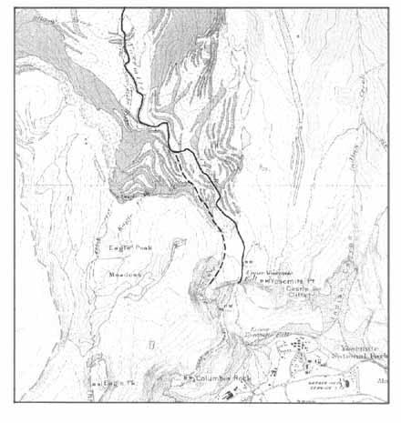 |
| Figure 6. Glacial morainal complex of probable Tahoe-age on Yosemite Creek that caused stream diversion to present channel. Open circles indicate scattered morainal material. Darkly-stippled arcuate areas indicate complex of moraine ridges as mapped by François Matthes (click to enlarge). |
While Matthes' moraines need to be remapped in light of our current knowledge of more numerous post-Sherwin episodes of glacial activity, they nonetheless offer a plausible explanation for the present-day location of Upper Yosemite Fall. The younger morainal deposits probably blocked the old channel of Yosemite Creek, which was then forced to find a new path though the intricate complex of nested moraines and was diverted on to its present site at the lip of the cliff.
The notch of the present Upper Fall is much smaller than the notch of the old Yosemite Creek leading to the abandoned ravine because the site was originally fed by only a very small stream and because there has been much less time—maybe hundreds of thousands of years less—for erosion there since the diversion of the much larger Yosemite Creek to it. Still, the present channel is cut fairly deeply in massive bedrock and is certainly pre-Tioga in age. Thus the present Yosemite Creek channel is probably at least as old as Tahoe in age, possibly older if diversion can be attributed to an unrecognized older glaciation.
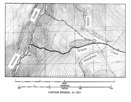 |
| Figure 7. Grouse Creek, flowing from right to left (heavy solid line), skirts the uphill side of a glacial moraine deposit (stippled area). Prior to diversion by the blocking moraine, Grouse Creek followed the heavy, dashed line down to the Merced Gorge (click to enlarge). |
Lending credence to the above explanation are several specific examples of stream diversions by glacial moraines in Yosemite, both from the latest glacial episode and an earlier one. An example of the latter that was described by Matthes is on Grouse Creek just west of the Wawona Road (Fig. 7), where he observed: “Grouse Creek, it would appear, has been deflected from its original lower course by a heavy embankment of glacial débris—the left lateral moraine of the Yosemite [Valley] Glacier—and it now follows a new course, having broken through the embankment at a point half a mile farther south.”7
Matthes did not locate this site on any of his published maps, but its probable location below the Wawona Road was deduced from a topographic map. My recent visit to the site with Jim Snyder, park historian, confirms Matthes' interpretation. The fortuitous preservation of this moraine is due solely to its diversion of Grouse Creek that has left it as a separate ridge along and outward from the canyon slope. This morainal deposit, some 2,000 feet above the Merced Gorge, is certainly old and is probably a product of the Sherwin glaciation. The degree of cavernous weathering of giant boulders mantling the deposit documents its considerable age (Fig. 8).
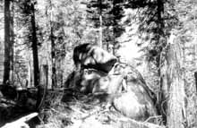 |
| Figure 8. Giant, cavernously-weathered boulder mantling the Grouse Creek morainal deposit. Park Historian Jim Snyder provides scale. (click to enlarge) |
Within Yosemite Valley itself, prior to the final Tioga-age glaciation, the Merced River probably flowed westward near the center of the valley. Blocked by the cross-valley ridge of the terminal moraine constructed by the Tioga glacier at Bridalveil Meadow, the melt water broke through along the north margin of the glacier to form a spillway near the north valley wall where the river still flows today.8
Following upvalley retreat of the snout of the Tioga glacier to just west of El Capitan Meadow, the glacier stabilized and the El Capitan recessional moraine ridge of bouldery debris was constructed across the valley, again obstructing the drainage. This time the melt water broke through along the south side of the valley to form a spillway near the south valley wall where the river remains today.8
Matthes' Wisconsin glacial stage and his mapped morainal complex on Yosemite Creek may include both the Tahoe and Tioga glaciations. If the foregoing diversion scenario for Yosemite Creek is valid, Upper Yosemite Fall, with its “newly” hanging valley, is less than one million years old and may be little more than 130,000 years old. And what a spectacular addition to Yosemite Valley's architectural wonders it is!
Footnotes
& References
1. Lafayette Houghton Bunnell,
Discovery of the Yosemite, and the Indian
War of 1851 Which Led to That Event
([1880], Reprint by Yosemite Association
[1990]) p. 182.
2. François E Matthes, Geologic History of the Yosemite Valley (U. S. Geological Survey Professional Paper 160 [1930]), p. 18.
3. G. I. Smith, V. J. Barczak, G. F. Moulton, and J. C. Liddicoat, Core KM-3, a Surface-to-Bedrock Record of Late Cenozoic Sedimentation in Searles Valley, California (U. S. Geological Survey Professional Paper 1256 [1983]), p23.
4. Robert Engberg and Donald Wesling, eds., John Muir, to Yosemite and Beyond (Salt Lake City, UT: University of Utah Press [1999]), p. 68.
5. John Muir, Yosemite Glaciers (New York, NY, New York Daily Tribune, [Dec. 5, 1871]), p. 8, cols. 5-6.
6. Matthes, Geologic History, p 112.
7 Matthes, Geologic History, p. 36.
8. N. King Huber and James B. Snyder, A History of the El Capitan Moraine (Yosemite Association, Yosemite, v. 64, no. 1, [2002]), p. 2-6.
ACKNOWLEDGMENT
I
am deeply indebted to James B. Snyder, Yosemite’s park historian,
for assistance in the historical aspects of this article.
Our Founder Questions? Go to About Our New Site |
Masthead
Photo from: |