|
|
|
Sierra Nature Notes, Volume 3, January 2003
The
Sierra Wave
by Beth Pratt
Vice President of the Yosemite Association
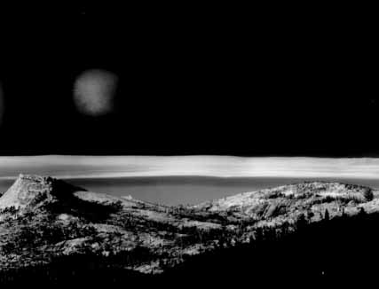 |
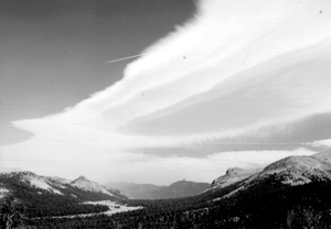
| Sierra Wave Cloud,1981, Yosemite National Park, courtesy of Bob Kolbrener. |
"Imagine
a world without clouds - nothing but clear blue sky from horizon to horizon,
365 days a year. What a monotonous world it would be, bereft of the imagery
of billowing castles, dragons, and winged steeds, deprived of the drama of
motion and shadow, innocent of the expectancy and foreboding that cloud changes
arouse in the human spirit."
Bette Roda Anderson, Weather in the West
The sky expresses itself in a poetry of clouds. That poetry resounds with a nautical flavor, for the sky is an ocean of air, an ocean we tend to forget for its invisibility. This sea of air does reveal itself in the clouds at times, its complexities and motions made perceptible. In a sense, clouds are the waves of the air, the visible manifestations of the atmospheric tide.
The Sierra Nevada adds its own special verse to the poetry of the sky. Known as the Sierra Wave, this cloud formation perfectly illustrates the sea above our heads. Imagine staring up at the sky on a clear day and being confronted by a white cloud that challenges the reach of the mountain range before you. Or suppose that you are standing beneath a giant crest of surf on the verge of breaking. Such is the Sierra Wave.
"Clouds always tell a true story, but one which is difficult to read," said meteorologist Ralph Abercromby. The story of the Sierra Wave not only reveals the truth of the weather behind a cloud, but it also discloses a landmark tale of scientific discovery.
 |
| Photo: Jeff Grandy |
Mountain Weather:
A Dance of Winds
The Sierra
Nevada has many unique characteristics that combine to create its Mediterranean
climate of short, wet winters and long, dry summers. Global weather patterns,
like the Pacific High, a high pressure system that moves north from the tropics
and acts as a barrier to the colder air moving south, affect the Sierra climate.
Local characteristics also exert their influence: extreme variations in elevation
(from 2,000 to 14,000 feet) and varied sun exposure lead to complexities in
atmospheric heating in the region.
The air runs a constant race with itself to move from high to low pressure - the race of the wind. The mountain range, for a variety of reasons, can be a very windy place, as anyone who has hiked over a lonely pass and been grabbed by a rush of wind knows. Turbulent gusts of mountain winds have been measured at over one hundred miles per hour, rivaling the speeds of hurricanes and tornadoes.
Winds originate both globally and locally. One of the standard patterns in mountain weather is the daily cycle of the valley-mountain wind. As the sun warms the craggy summits and granite ridges in the morning, the warmed air rises, and creates a low pressure void that the colder air from the valley rushes to fill. In the evening, the flow of air reverses as the slopes cool more rapidly than the valley below and the air sinks from the ridges, creating a down-mountain wind.
Regional and global weather systems can both augment and disrupt the localized patterns. The wind that may have traveled westward from the sea, flows up the windward side of the mountain, passes over the summit, and flows down on the leeward side into the desert. As the wind travels from the open valleys to the more confined spaces of the mountains, it compresses and increases in speed. Depending on their velocity, these invading winds can wrestle control from the local breezes.
Like the currents in the sea, the complex mountain winds swirl and shift, dance and laugh, and tease and taunt the landscape. And borne of this jumble of winds is the Sierra Wave.
 |
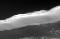
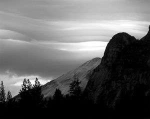
| Lenticulars
form over the Sierra Crest. Photo: Shad Stites |
Enormous Lenticular
Clouds
On the
beginning of a hike to the Kuna Crest last year, we slowed our steps when
we observed an enormous cloud, eerie in its stillness, that guarded the majority
of the sky. My partner snapped photographs, while I considered the cloud from
every angle. An amateur weather buff, I add clouds to my life list like an
ornithologist collects bird sightings. I've seen many wind-formed lenticular
clouds, in various shapes and sizes (some resemble UFOs, others giant pancakes),
but this cloud's size was of a far greater scale. I had read about the Sierra
Wave but had never seen the phenomenon "in the wild" until now.
The cloud haunted us all day, its massive reach dominating an otherwise clear sky. For the six hours that we hiked, it remained in its original position, neither gaining nor losing shape. It suggested a tidal wave, frozen in ice. During our lunch at Kuna Lake, some of the most turbulent winds I've ever experienced in the Sierra playfully attacked us, bending tree tops and making me chase a candy wrapper for a quarter of a mile. These boisterous winds were part of the system that had produced the wave.
The Sierra Wave is a type of lenticular cloud, and depending on its height, is named cirrocumulus lenticularis, altocumulus lenticularis, or stratocumulus lenticularis. Clouds come to life from the condensation of the water content of the air. Lenticulars are formed by high, intense winds that lift off as they rapidly gain elevation; the lifting creates wave patterns of air where condensation takes place. Depending on the variations of temperature and moisture in the air, the condensation level can be quite pronounced, as in the flat bottoms of cumulus clouds, or in the distinct contours of the Sierra Wave.
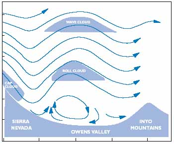 |
| The formation of lenticulars over the Sierra Crest. |
A combination of factors must exist for the wave to appear in the sky-moderate to strong winds blowing perpendicular to the mountains, adequate moisture in the air, and a stable airflow aloft. And although wave clouds can occur at any time of year, they are most common in the winter months.
The wave begins when a strong, constant, west wind rushes up the peaks. If conditions are right (and the exact conditions are still not fully understood), the wind doesn't all descend down the leeward side of the mountain as it would normally. Instead, it rises above its original altitude and creates a series of waves. On the leeward side, turbulent winds nearer to the ground (rotors) play into the complex pattern. The often-cited comparison is to water running over rock. Fast moving water will pass over a protruding stone and create an immediate dip, but a subsequent wave or waves will then develop further downstream.
About five to ten miles downwind, the wave form usually emerges, although this distance can be extended. The reach, or trough, between each wave can be from two to twenty miles. The upward motion of the wave can extend into the stratosphere, over 60,000 feet into the sky, while the up and downdrafts of the air flow rise and fall at speeds of between 2,000 and 4,000 feet per minute.
From this complex ballet of air motion emerges the Sierra Wave. Although the cloud appears stationary, it is actually a dynamic system, constantly replenished with the flow of air in the same way a waterfall is constantly refilled with water. As the wind blows upwind, the air cools and condenses, forming the lower edge of the wave. Beyond the crest, on the downwind side, the air descends and evaporates, creating the outer edge of the wave. The wave forms and reforms, gaining and losing size as the flow of the wind varies.
Companion clouds-a cap cloud creeping over the windward side of the mountains, and small cumulus clouds under the wave demonstrating the turbulent rotors-may accompany the wave formation.
 |
The Sierra
Wave Project
For
those of us who prefer to travel by land, the cloud remains a wonderful spectacle
to photograph. But for those who soar in the air, the cloud is simply a picturesque
side note to the action behind it. The airflow in the waves provides challenging
conditions that enable glider pilots to soar to record breaking heights. Until
the 1950s, however, the significance of these mountain waves was not fully
understood.
Soaring pilots had always assumed that lee winds produced downdrafts, and consequently had avoided flying on the lee sides of mountains. They sought out, instead, the convective airflow of thunderstorms for lifting them into the higher altitudes. In 1933, a glider instructor gazed up at his student soaring aloft off the lee side of Germany's Riesengebirge Mountains and smiled in puzzlement. To satisfy his curiosity, the instructor boarded a glider and experienced the impressive lifting qualities of the wave for himself. His documented findings caught the attention of Joachim Kuettner, a doctoral candidate in meteorology, who began to study this phenomenon.
Far across the world, another pilot had noticed the strange clouds and atypical winds, and began theorizing about their formation. Bob Symons, a "versatile, energetic, visionary," was a Bishop, California native, who, while running his ranch, somehow found time to develop his talents in aviation, engineering, mechanics, and photography.
Symons partnered with another pilot, Harland Ross, to start a flying service in 1947. Together, they take credit for discovering the Sierra Wave in their flights. In order to explore their new discovery, they sponsored several events known as Bishop Wave camps (the original name for the wave), where pilots were invited to explore the unique flying conditions. They were the unofficial roots of the Sierra Wave project (Bob Symons began calling the phenomenon the Sierra Wave after World War II).
In 1949, a B-29 pilot was flying over the mountains in California and encountered unusual wind patterns. He consulted a meteorologist about the conditions, who noted the similarities to the work of the German scientist Joachim Kuettner. When further explorations were ordered, the genesis of the Sierra Wave project began.
 |
| Photo: Jeff Grandy |
To study the Sierra Wave, the U.S. Air Force, U.C.L.A., and the Southern California Soaring Association sponsored what was the first international meteorological study. The agencies recruited an assembly of talent from around the world, including Bob Symons and Harland Ross, scientists Dr. Wolfgang Klemperer and Dr. Joachim Kuettner, meteorologist Harold Klieforth, engineer Vic Saudek, and skilled pilots John Robinson, Ray Parker, Paul McCready, Betsy Woodward, Larry Edgar, and Bill Evans, Jr.
Using instrumented sailplanes to conduct research, the team sent pilots soaring into the sky to try and determine the airflow patterns and the size and reach of the wave. A reporter remarked to Paul MacCready before one of his flights that "You look like you're getting ready for a date with a cloud." During one excursion, team members Klieforth and Edgar set a still unbroken soaring record by ascending to 44,255 feet in a two-person sailplane.
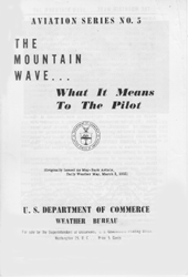
Their work produced scientific advances in mountain lee wave study, most notably the finding that the waves extended 60,000 feet into the stratosphere. Another result was that the project later evolved into the first systematic study of the jet stream. Commercial aviation also benefited from the new information; pamphlets like the one shown were produced detailing the hazards of flying in mountain lee waves. These scientific discoveries and record breaking flights were all prompted by curiosity about the spectacle of an unusual cloud in the sky.
The Mountain
Shore
In
his wonderful book, The Invention of Clouds, Richard Hamblyn writes
that "weather writes, erases, and rewrites itself upon the sky with the
endless fluidity of language." The Sierra Wave is written by the winds
and serves as a reminder of the sea of air above us. Venture into the mountains,
climb to the shore of the sky, and if conditions are right, like Clarence
King in Mountaineering in the Sierra Nevada, you just may glimpse "the
dark swelling Sierra wave thrusting up 'star-neighboring peaks.'"
Sources
Anderson, Bette Roda. Weather in the West (Palo Alto, CA: American West Publishing, 1975).
Hamblyn, Richard. The Invention of Clouds (New York: Farrar, Straus & Giroux, 2001).
Huning, James R. Hot, Dry, Wet, Cold and Windy: A Weather Primer for the National Parks of the Sierra Nevada (Yosemite, CA: Yosemite Association, 1978).
Smith, Genny, ed. Sierra East: Edge of the Great Basin (Berkeley: University of California Press, 2000).
U.S. Department of Commerce. The Mountain Wave…What it Means to the Pilot (Washington, D.C.: U.S. Govt. Printing Office, 1955).
Whelan, Robert. Exploring the Monster: Mountain Lee Waves: The Aerial Elevator (Niceville, FL: Wind Canyon Books, 2000).
Whiteman, C. David. Mountain Meteorology: Fundamentals and Applications (New York: Oxford University Press, 2000).
On the Web
Lenticular
Cloud Formation with good graph.
PSC Meteorology
Program Cloud Boutique
Cloudman: Photos and
explanations of cloud formations.
Our Founder Questions? Go to About Our New Site |
Masthead
Photo from: |