|
|
|
Understanding
Smog in the Sierra
by E. F. van Mantgem, a smooth operator (meteorological
station operator) for Sequoia and Kings Canyon National Parks
Introduction:
the Fun in Knowing about Air
The
best part of learning about air quality is that by dabbling in knowledge about
this essential gas, you begin dabbling in the worlds of everything. Animals,
vegetables, and yes, even minerals are affected by rampant air pollutants.
By knowing this, a resourceful air quality buff could potentially get to do
a lot of fun stuff. In the name of science, he or she might get to band fluffy
birds one day, then frog-hunt by helicopter the next. The pyromaniacs in the
crowd might enjoy helping with a controlled burn to reduce wild fire smoke
hazards. Ski addicts could measure acid rain on an extended, powdery ski patrol.
Air quality science is such a holistic discipline that it takes broad, flexible
minds from all niches of the world to master it. Maybe like yours!
 |
 |
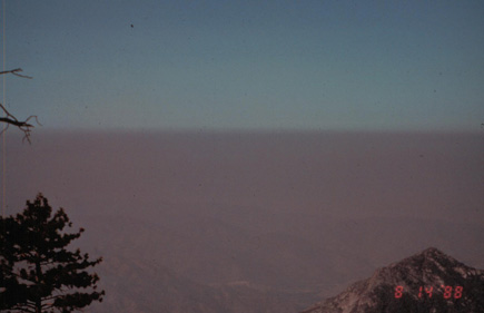 |
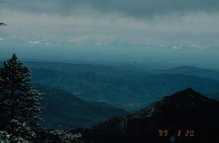
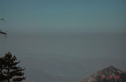
| The Good, The Bad and The Ugly: Same views, different air, from Sequoia National Park looking west into the San Joaquin Valley. |
I. Air Quality Research Explained
"Air
pollutants" are really just unwanted, airborne chemicals. The chemicals
might begin as something happy, like a cozy wood fire or a gallon of gas for
the lawn mower, but they've ended up as something unpleasant, like smoke,
haze, or an invisible ground layer of ozone. Now that humans are producing
a lot of stinky, ugly, expensive, and damaging air pollutants, we need to
measure them on a regular basis, a practice commonly known to resource managers
as monitoring.
Nephalometers, transmissometers, spectrophotometers and telephotometers are just a few of the odd sounding tools that scientists are using to measure air pollutants. By measuring air pollution in all its forms over time and space, researchers are able to identify air pollution source, sink, and receptor locations. These respective locations are the places where air pollution is formed, where it aggregates in high concentrations, and where it chemically changes the environment.
|
Auto-emissions,
industrial emissions and power generation emissions produced in places
like the Bay Area are eventually transported into the Sierra... .
|
As pollution trends are discovered by researchers, pollution-literate people can produce effective strategies for reducing this self-inflicted mess. In other words, the measured results of the research point us toward logical solutions.
For example, the economic impacts of air pollution become clear when hourly ozone averages are collected at over 40 nationwide sites for years at a time. When painstakingly accumulated data sets like this are mathematically compared to other long-term data sets (i.e., weather pattern data, agriculture profit margin data, wildlife population data, regional ozone damage data, and local health data), we discover that ozone and other air pollutants are clandestine villains, smothering the national landscape. We've discovered that the quality of American air is directly correlated with the quality of American life, and we have reams of numbers to prove it.
II. Air Pollution
Trends in the Sierra
While nobody in California wants to be the cause of happy chemicals gone bad,
long-term monitoring has consistently shown human populations to be the single
most important source of air pollution. In the Sierra Nevada, human activity
and industry is clearly tied to poor air quality. In other words, auto-emissions,
industrial emissions, and power generation emissions produced in places like
the Bay Area are eventually transported into the Sierra, traveling hundreds
of miles and picking up pollutants like agricultural aerosols and dust on
the way.
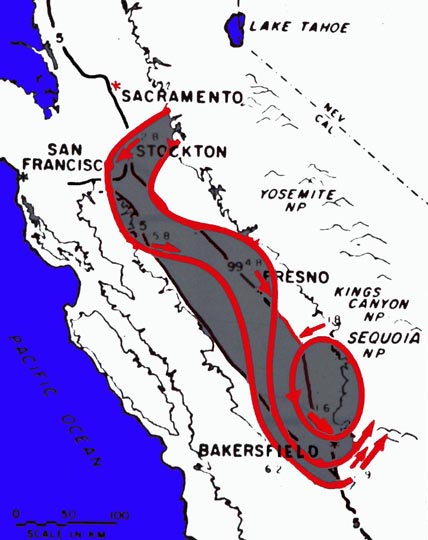 |
| Typical California air circulation from about April through October. Southward moving air picks up pollutants from the San Francisco Bay Area and the San Joaquin Valley, eddying them up against the southern Sierra. |
Generally speaking, the southern Sierra is suffering more than the northern Sierra, mostly because of the regional weather patterns over a state with an extremely variable topography. Because of a giant, counter-clockwise rotation of state-wide air, the pollutants are immediately moved southeast from the Bay Area, across the Bakersfield area, then wedged snugly against the west side of the Sierra double-crest. With Mt. Whitney and the other 14,000 plus foot mountains blocking escape, this air pollution accumulates in outrageously unhealthy concentrations.
This weather
system is not unlike the swirling pattern of a giant toilet bowl, with the
southern Sierra as the percolating ground for some of the highest nitrate,
soil, and organic particulate matter (PM) pollution in the country. Agriculture
practices like plowing and harvest create fine, airborne dust that never settles
until the first winter rains, as do the desiccated Mono Lake and Owen's Lake
lakebeds on the east side of the Sierra. The PM pollution in the southern
Sierra is actually aggravated by the dry soil conditions in the Summer season,
as well as by wildfires and crop dust.
In contrast, the wintertime is enviably clean in the Sierra. Lucky for me
and other high elevation residents, stable winter inversion layers over the
California valleys trap auto emissions below 1,000ft., keeping us free of
acid rain and particulate matter. As a result the Sierra has some of the most
pristine air in the country during wet, winter seasons. During unstable storm
periods, rains from the Pacific usually scrub the air clean before air pollution
can reach us.
Unfortunately, our lower elevation neighbors receive the dirty rainwater; plus, they're the ones stuck underneath the stable inversion layers. Throughout most of the winter, valley residents are submerged in a concentrated mist of acid rain droplets — a toxic tule fog. On a more positive note, the lack of wintertime sunshine in the valley means that auto emissions are never converted to ozone, essentially rendering ozone pollution absent from the valley's otherwise long list of winter problems. Continued
Our Founder Questions? Go to About Our New Site |
Masthead
Photo from: |